By Ashley Peele

Field Sparrow Nest by Bob Schamerhorn
This is the third of the VABBA2 data entry tutorials. If you missed the first two, check them out here:
Tutorial 1: Recording incidental checklists
Tutorial 2: Submitting complete checklists
In this article, we will focus on location precision. The main messages are:
- Rather than reporting everything from your block at a single location, make a number of sub-locations within your block representing different regions, especially habitat types, properties, or counties when it’s feasible.
- Aim to make the distance covered for your checklists less than 2 miles. This ensures that the birds you observed are relatively close to the point at which you plotted them.
- Use the tools we’ve provided to help navigate accurately through your Atlas block.
Why is this important?
The first VA Breeding Bird Atlas (VABBA1) reported all bird species at the block level, so all of the data from VABBA1 is linked to the center point of a given block. For example, if we use the USGS BBA Explorer tool (click here: USGS BBA Explorer), we find that Pine Warblers bred in the Bon Air SE block in the late 1980s.
But what if we are interested in learning more about those Pine Warblers, to study or protect the nesting habitat? From these data, we don’t know where they were breeding. In this particular instance, we don’t even know if the Pine Warbler nested in Chesterfield county or Richmond City (Figure 1).
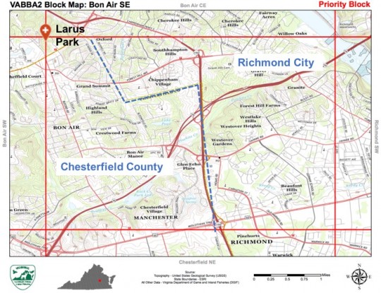
Figure 1. Bon Air SE Priority Atlas block. Note: county and city lines divide this block (blue dotted line). This is a pdf map downloaded from the VABBA2 Block Explorer tool. Every block has these maps for download. See below for how to use these maps on your smartphone.
For checklist purposes, it would be much more informative to use the park or property (e.g. golf course) where the species nested.
This is similar to how locations and hotspots are parsed out in general for eBird — we tend to think only about making points for locations that we visit again and again — but in this case, you should think about dividing up your atlas block into discrete units you will likely visit repeatedly.
Special reminder: PLEASE BE CAREFUL IF USING EXISTING HOTSPOTS AS ATLAS LOCATIONS! HOTSPOTS OFTEN CROSS BLOCK LINES.
- In the above example, you could have selected the ‘Larus Park’ hotspot. But before you select a hotspot, you must check where block lines fall! Block lines are pesky, and often cut right through existing hotspots. In this example, Larus Park sits in 4 different blocks (ack!). This kind of thing is somewhat unavoidable, when using a uniform grid system.
- To avoid plotting your location in the wrong block, always use the “Find it on a Map” option when plotting your location to pull up the atlas block grid and check where current hotspots fall.
- Selecting something like the ‘George Washington NF’ hotspot will likely not get your birds plotted anywhere near where you saw them!
Why does this matter??
When locations are plotted with greater precision, the information becomes much more valuable for data users, such as land managers and scientists. Researchers are often looking to use eBird data to make predictions about landscape-level bird use. If you report a Blue Grosbeak on a checklist with a large forest location instead of farmland where you saw it, this could reduce the accuracy and usefulness of these models.
The Virginia Society of Ornithology’s seasonal summaries in Virginia Birds do a great job of reporting bird records by county and region. Making sure your birds are plotting out to the right county can assist in maintaining consistent bird records. eBird also aggregates data by county in several places, including the general Explore Data tools, county and block summaries for the Atlas, and also on your personal lists on the My eBird tab.
So how should you break up your block?
Obviously we’re looking to strike a balance between providing locations that are useful, yet keeping your data entry manageable. It will likely vary by block, based on the habitat types, properties, and access within a block, plus different people might do it in different ways.
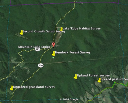
Figure 2. Eggleston NE Atlas Block. Note survey point locations based on habitat types.
Here’s one way you might divide up points (Figure 2). Notice some of these sub-locations are based on habitat type and others are just a general midpoint of a road or a large forested area. Sometimes, points may be based on land ownership and property boundaries.
If you’re curious, you can’t find the above map in a single location. I used the Google Earth Block layer (available as a kml file on the Atlas maps page) and added labeled points for survey locations. Anyone can download Google Earth to their computer or smartphone and us this Block layer map to explore their block(s).
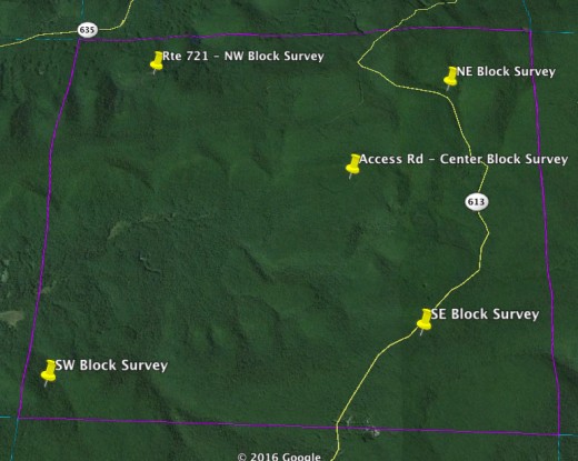
Figure 3. Interior SE Atlas Block. Survey locations based primarily on accessibility.
If you have a fairly uniform block with regard to both habitats and properties, you might use fewer points. You could just divide your block up into 4 quarters, or select major roads as center points for your routes. Here is an example of a block with relatively similar habitat and only a few roads into it:
Navigating your block!
To assist you as you explore your blocks and figure out where to go and how to divide those checklists, we have several handy tools on the atlas website.
The simplest are downloadable PDF maps for each atlas block, which identify your block boundaries and roads. These can be downloaded from the VABBA2 Block Explorer tool.
A phone app called Avenza PDF Maps can be downloaded on to most smartphone platforms and used to navigate around your block. After recent changes, you can download up to 3 maps for free or pay an annual subscription for unlimited maps. (It worked to well, so they started charging!)
Steps for using AVENZA Maps:
- Use the App Store (iPhone), Windows Phone store (Windows) or Google Play (Android) to search for the ‘Avenza PDF Maps’ app. Once found, download the free app to your phone.
- Next, use your phone’s internet browser (e.g. Safari for iPhone or Chrome for Android) to navigate to the VABBA2 Block Explorer Tool.
- You can do this by going to www.vabba2.org and clicking one the ‘Atlas Block Explorer’ link in the Maps and Tools page. Click first link:
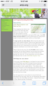 Takes you to:
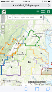
- Or you can just enter in https://amjv.org/vabba/maps-and-tools/ to your web browser address bar.
- You can do this by going to www.vabba2.org and clicking one the ‘Atlas Block Explorer’ link in the Maps and Tools page. Click first link:
- Search for your Atlas block, then click on the block, click on the arrow,
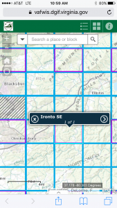 click ‘Download Topo’:
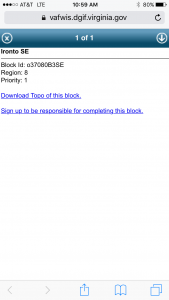
- For iPhone: This will take you to a new window where the PDF map will appear. A drop down screen will allow you to select ‘Open in…’,
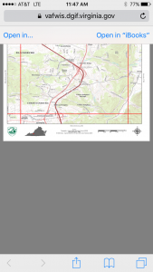 then ‘Copy to PDF Maps’.
 - For Android: a pop-up window will tell you that the map is downloading. Once downloaded, a new pop-up will ask where to open the file. Select ‘Open with PDF Maps’. You may be asked to agree to a terms of service and to register. You can either create an account now or just skip this step.
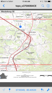
- Once your map is downloaded into the PDF Maps app, you’re good to go!
- You can drop pins to mark locations on your map and make notes. Just remember that these maps will only show your location, if you are actually in your block. Don’t be alarmed if you see no blue dot to indicate where you are, if you aren’t standing in the block. A blue dot will pop up when you enter it.
Your phones built-in GPS will allow you to navigate around your block(s), even when you have no cell service.
As always, remember to seek out advice on these topics from your regional coordinators or the VA Atlas Coordinator (contact info here).
[This tutorial has been modified with permission from those created by WI Coordinator Nicholas Anich for the WBBAII and we thank him and our sister Atlas for generously sharing these resources with the VABBA2!]


