
By John Page Williams
Photos by John Page Williams
Jones Creek is one of two large tributaries to the Pagan River, flowing into it near its confluence on the south side of the lower James, across from Newport News. The Pagan watershed was home to Native people for centuries before English colonists arrived in 1607, offering them the full range of rich natural resources they needed for their Late Woodland culture. Captain John Smith knew these people as Warraskoyack. He traded with them for corn, and the Jamestown colony enjoyed general friendly relations with them at first. By 1622, however, English settlers had begun crowding the Warraskoyack off their lands, so they participated in the widespread massacre of colonists organized and led by Chief Powhatan’s brother and successor, Opechancanough.
By the mid-1630s, though, English settlers began returning to the territory and established one of Virginia’s first eight shires there in 1634, ironically naming it Warraskoyack. Three years later, they renamed it Isle of Wight, and so it has remained since then. They also renamed the river Pagan, anglicizing the Indian name for the pecan trees that flourished there early in that century. That same year, they colonized the high bank where the Pagan receives the flow from Cypress Branch, a powerful tributary. The protected deep water formed a natural port for shipping the tobacco that the colonists quickly began growing and exporting to England. It lies close to the site where John Smith’s map records the King’s House (town) of the Warraskoyack. The map also locates an Ordinary House (village) named Mokete roughly where the watermen’s village of Rescue lies, at the point where Jones Creek joins the Pagan, just before it flows into the James.
Jones Creek is named for settler Giles Jones, who patented land along it above Mokete sometime before 1618. It drains a generally forested watershed for six miles from the crossroads at Benns Church to Rescue. Jones Creek Landing, managed jointly by the Department of Wildlife Resources (DWR) and Isle of Wight County, lies at the eastern boundary of Rescue.
Rescue is a classic watermen’s village, a natural for the profession because of its proximity to the fabled seed oyster beds on the James River’s shoals in lower Burwells Bay, just outside the Pagan’s mouth. On a visit last fall, a friend and I took note of the oyster leases marked by PVC poles on the shoals just outside the Pagan’s mouth. The James is a little over four miles wide here, with Blunt Point and Indigo Lake in Newport News on the other side.
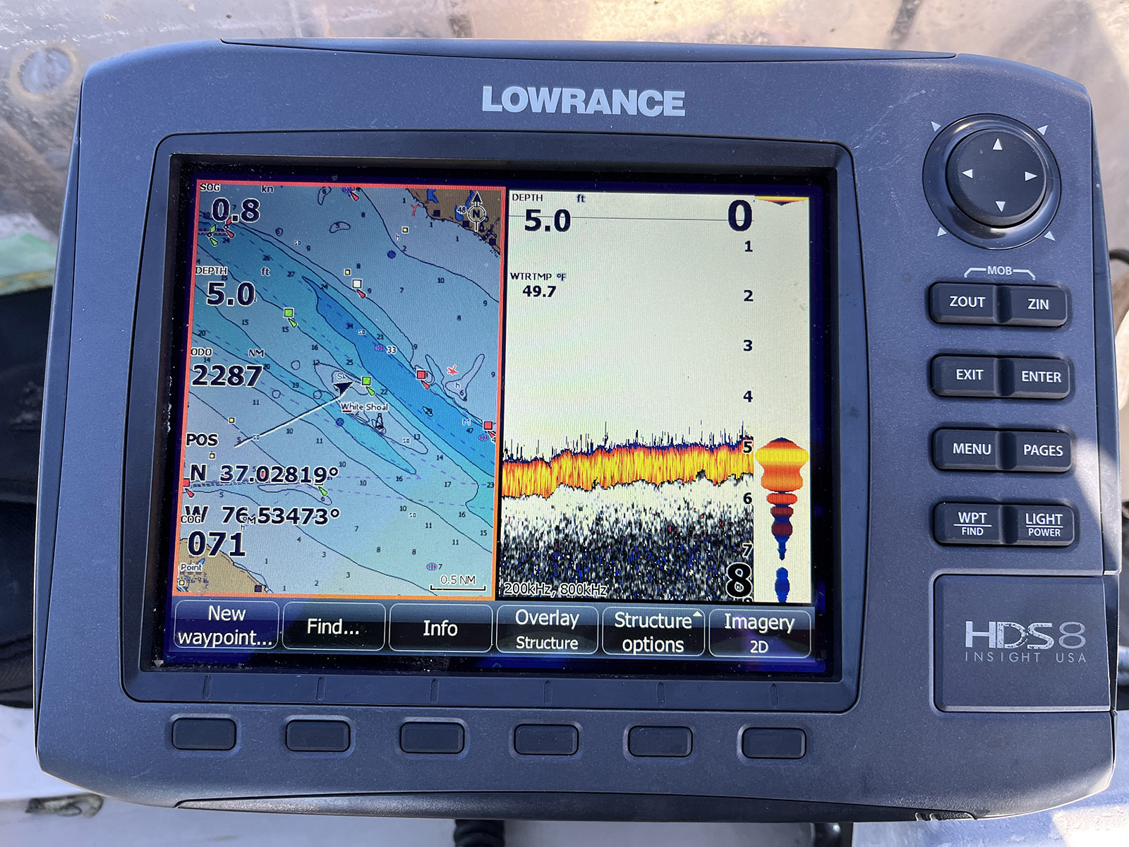
The sonar chart around White Shoal.
Take a look at the number of oyster leases and the large public harvest areas there in this map from the Virginia Marine Resources Commission. We marveled at how the big river has cut two channels, flowing around White Shoal, where our sonar showed a depth of only five feet in the middle of this broad expanse of water. The combination of channel edges, shoals, and current eddies has created the Chesapeake’s largest oyster nursery. No wonder the harbor at Rescue Yacht Basin was full of workboats with patent tong rigs when we visited. Or that Capt. Chuck-A-Muck’s Restaurant at the Yacht Basin serves local oysters in many forms.
Up the Pagan at the port, Arthur Smith IV formally laid out the town of Smithfield in 1752, building an estate along Cypress Branch named Windsor Castle. Early settlers in the town found that the Southside Virginia climate worked well for raising hogs, especially if fed crops of locally grown peanuts that also flourished there. Capt. Mallory Todd developed a distinctive salt and smoke cure for the resulting Smithfield hams, allowing them to be shipped out as an additional export. After tobacco culture began to wane, the town became a center for processing and shipping peanuts. In 1880, peanut merchant P.D. Gwaltney began smoking and shipping hams as well, passing the business on to his son in 1914. However, a devastating warehouse fire in along the riverfront in 1921 caused the town’s peanut business owners to move their operations east to Suffolk.
Meanwhile, in 1926, Virginia’s General Assembly passed a statute defining “Smithfield ham” by law, including the requirement that it be processed within the town limits. In 1936, the Luter family, who had worked for P.D. Gwaltney, established Smithfield Foods, which has grown since into the world’s largest pork processor and hog producer (including acquisition of P.D. Gwaltney & Company).
The company remains a major employer and patron of the town. One particular amenity it has provided is Clontz Park, including a fishing pier, a launch ramp, and a walking trail. Another feature is Smithfield Station, a waterfront marina with an inn and restaurant.
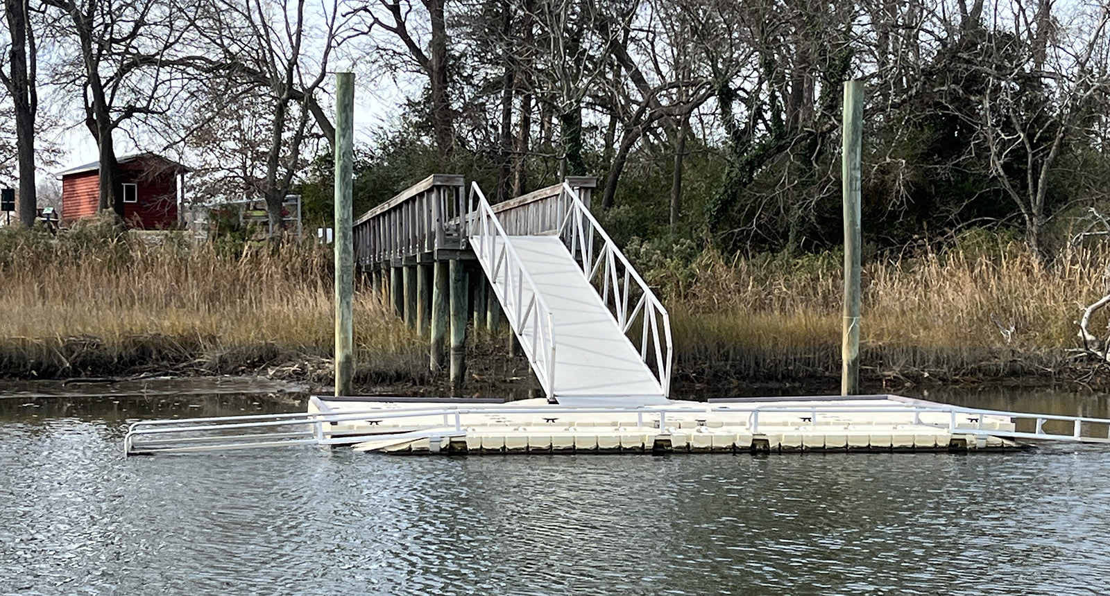
The kayak launch at Windsor Castle.
A highlight of the town is Windsor Castle Park, built on the former estate of Arthur Smith IV. It includes more trails and an excellent dock to launch paddlecraft for exploring Cypress Branch. The park is a recommended location on the Tidewater Loop of DWR’s Bird and Wildlife Trail. That waterway also has a deep channel and is well worth a look if a visitor has run a powerboat up the Pagan from Jones Creek. So is the main stem of the Pagan, which winds west along the town’s architecturally attractive riverfront, bends past Clontz Park, and wanders off between marshes into the interior of Isle of Wight County. It’s lovely, but be careful if the tide is low, even if piloting a shallow-draft skiff.
Fishing? From fresher water in Jones Creek and Cypress Branch to the Pagan’s marsh creeks and the saltier oyster reefs of the James, there are plenty of opportunities here. The upstream waters hold white and yellow perch, plus white and blue catfish. Depending on how much fresh water is coming down the James, they could be in lower Jones Creek and the Pagan as well. The oyster reefs hold spot, croakers, and blue cats. Two bonus areas are the James River Bridge, four miles downstream of the Pagan’s mouth, and DWR’s Ragged Island Wildlife Management Area at its south end. Between the bridge pilings and Ragged Island’s salt marshes, there are opportunities for rockfish (striped bass), speckled trout, and redfish from late spring through fall.
If the Warraskoyack people and Capt. John Smith visited Jones Creek and the Pagan River today, they would be surprised to see Smithfield, but they would feel right at home in the river and its surrounding woods and wetlands. Despite the proximity to Suffolk and Newport News, these waterways are still rural, inviting exploration for enterprising birders, anglers, and historians in paddlecraft and skiffs.
John Page Williams is a noted writer, angler, educator, naturalist, and conservationist. In more than 40 years at the Chesapeake Bay Foundation, Virginia native John Page championed the Bay’s causes and educated countless people about its history and biology.
