
- Bait Allowed
- 9-inch Minimum
- 16-inch Minimum, 2 Fish Per Day
- 20-inch Minimum, 1 Fish Per Day, Flyfishing Only
- Catch and Release Only
Get Landowner Permits Online!
Written landowner permits required to fish Buffalo Creek, Upper South River, and Mossy Creek are now available online. See each waterbody below for more information and maps.
Bait Allowed
Jackson River Tailwater (Alleghany County):
From Gathright Dam downstream to the Westvaco Dam at Covington: No rainbow trout 12 to 16 inches; no brown trout less than 20 inches; 4 trout (combined rainbow and brown) creel (harvest) limit per day, only 1 of 4 can be a brown trout over 20 inches. All rainbow trout between 12 and 16 inches and all brown trout less than 20 inches must be released immediately.
The 7-inch statewide minimum size limit does not apply to rainbow trout in this section of river. Bait allowed.
Lake Moomaw (Alleghany/Bath Counties):
The entire reservoir has the special 16-inch minimum size limit and 2 fish per day creel limit on trout. Bait allowed.
Smith River (Henry County):
From Philpott Dam downstream to the State Route 636 bridge crossing (Mitchell Bridge) located approximately 31 miles downstream of Philpott Dam and approximately 10.5 miles below Martinsville Dam: No brown trout 10 to 24 inches, only 1 brown trout per day longer than 24 inches. The length limit for rainbow and brook trout is 7-inch minimum. The creel limit for all trout combined is 6 fish/day, and only one brown trout can be larger than 24 inches. The use of bait and any combination of artificial lure is allowed throughout this section of river. (A trout license is required in the Put-N-Take stocked sections of Smith River October 1 through June 15.) Bait allowed.
South Holston Reservoir (Washington County):
7 per day creel (harvest) limit, only 2 of 7 can be a Lake trout; no length limits. See licenses and regulations in the reciprocal section. . Bait allowed.
Regulations for the 9-inch, 16-inch/2 fish, 20-inch/1 fish, and Catch and Release trout stream sections that follow:
- Only single-point hook artificial lures may be used unless otherwise noted (see artificial lure definition).
- No bait may be in possession while fishing these waters unless otherwise noted.
- All trout less than the minimum size must be immediately returned to the water unharmed. No trout less than the minimum size may be in possession while fishing in these waters.
9-inch Minimum
Big and Little Wilson Creeks and their tributaries, Quebec Branch, Wilburn Branch, and Mill Creek (Grayson County):
That portion within the Grayson Highlands State Park and the Jefferson National Forest Mount Rogers National Recreation Area. With the special regulation on Cabin Creek (see below), all of the streams within Grayson Highlands State Park are under one regulation. Access can be gained through Grayson Highlands State Park on Route 806 and 817 off U.S. Route 58.
Be prepared to do some hiking to fish this area.
Cabin Creek (Grayson County):
That portion of stream and its tributaries within the Grayson Highlands State Park and the Jefferson National Forest Mount Rogers National Recreation Area. See above for more information on the area.
Conway River/Devils Ditch (Greene and Madison Counties):
That portion of Conway River and its major tributary, Devils Ditch, within the Rapidan Wildlife Management Area (WMA) and the Shenandoah National Park. The stream lies north of Stanardsville and can be reached by Route 615 from Graves Mill.
Garth Run (Madison County):
That portion of stream within the Rapidan WMA. The stream can be reached by Route 615 from Graves Mill. Most of the stream is accessible only by foot as the streams enters a gorge.
Little Stony Creek (Giles County):
That portion of stream within the Jefferson National Forest. The stream is located near Pembroke and can be reached by Route 623.
Little Stony Creek (Shenandoah County):
That portion of stream within the George Washington National Forest, including Woodstock Reservoir. The stream is located west of Woodstock and the Forest Service Road 92 crosses the lower portion of the special regulation section.
Much of the upper reaches can only be reached by foot trail.
Mill Creek (Giles County):
That portion of Mill Creek and its tributaries upstream of the Poplar Street Bridge in the Town of Narrows (Mill Creek flows through the National Forest in Giles County and the Town of Narrows.) The stream can be accessed from a parking area on Northview Street, off of State Route 100, south of Narrows.
North Fork Buffalo River (Amherst County):
That portion of the stream and its tributaries within the George Washington National Forest.
Access is available by a forest trail off Forest Road 51 or from the end of State Route 635.
St. Mary’s River (Augusta County):
All portions of the stream and its tributaries above the gate near the George Washington National Forest property line. The stream lies east of Raphine off Route 608, a short distance from I-81. Most of the area is accessible by foot trail only and backpacking is popular.
Ramsey’s Draft (Augusta County):
That portion of the stream and its tributaries within the George Washington National Forest.
To reach this stream, drive 15 miles west of Churchville on Route 250 and look for the Mountain Home Picnic Area on the right; a foot trail parallels the stream from the picnic area.
16-inch Minimum, 2 Fish Per Day
*Buffalo Creek (Rockbridge County):
That portion from the confluence of Collier’s Creek upstream 2.9 miles to the confluence of North and South Buffalo creeks. The stream flows through private land and *a free written landowner permit is required to fish these waters. A no-cost permit can be obtained DWR’s Go Outdoors Virginia website.
*Dan River (Patrick County):
That portion from Talbott Dam approximately 6 miles downstream to a sign posted just upstream from the confluence of the Dan River and Townes Reservoir. The upper reaches can be reached by taking Route 614 south from Meadows of Dan, turn right on Route 601, and proceed to Talbott Dam. The lower reach can only be accessed by boat at the upper end of Townes Reservoir. *A permit from Northbrook Virginia Hydro LLC is required and information about permits can be obtained by calling 276-251-5141.
Jackson River (Bath County):
That portion from the Forest Service swinging bridge, located just upstream from the mouth of Muddy Run, upstream 3 miles to the last ford on Forest Service Road 481D. This section is stocked several times a year with catchablesized trout and good populations are always present (a trout license is required to fish in this stream from October 1 through June 15).
This section can only be reached by foot travel, either from the Hidden Valley area or off Route 623 and FS Road 481. Note: Multiple hook artificial lures are permitted.
Pound River (Dickenson County):
That portion from a sign 0.4 miles below Flannagan Dam downstream 1.2 miles to a sign just upstream of the confluence of the Pound River and the Russell Fork River. The section can be accessed from Flannagan Dam, which is owned and operated by the U.S. Army Corps of Engineers.
Roaring Run (Botetourt County):
The 1-mile special trophy trout section is located in the Jefferson National Forest between the third foot bridge upstream of the Roaring Run Furnace Day Use Area and the Botetourt/ Alleghany County line. The stream can be accessed by taking Route 615 off US Route 220 west of Eagle Rock to Route 621 at Strom. The lower section of Roaring Run (within the National Forest) remains catchable stocked trout water.
South Fork Holston River (Smyth County):
This section includes approximately 4 miles of stream extending from 500 feet above the concrete dam at Buller Fish Hatchery, upstream to the upper Jefferson National Forest boundary (above the crossing of the Appalachian Trail).
This section is located South of Marion and west of the community of Sugar Grove off Route 16. Anglers can access most of this section from Route 670.
20-inch Minimum, 1 Fish Per Day, Flyfishing Only
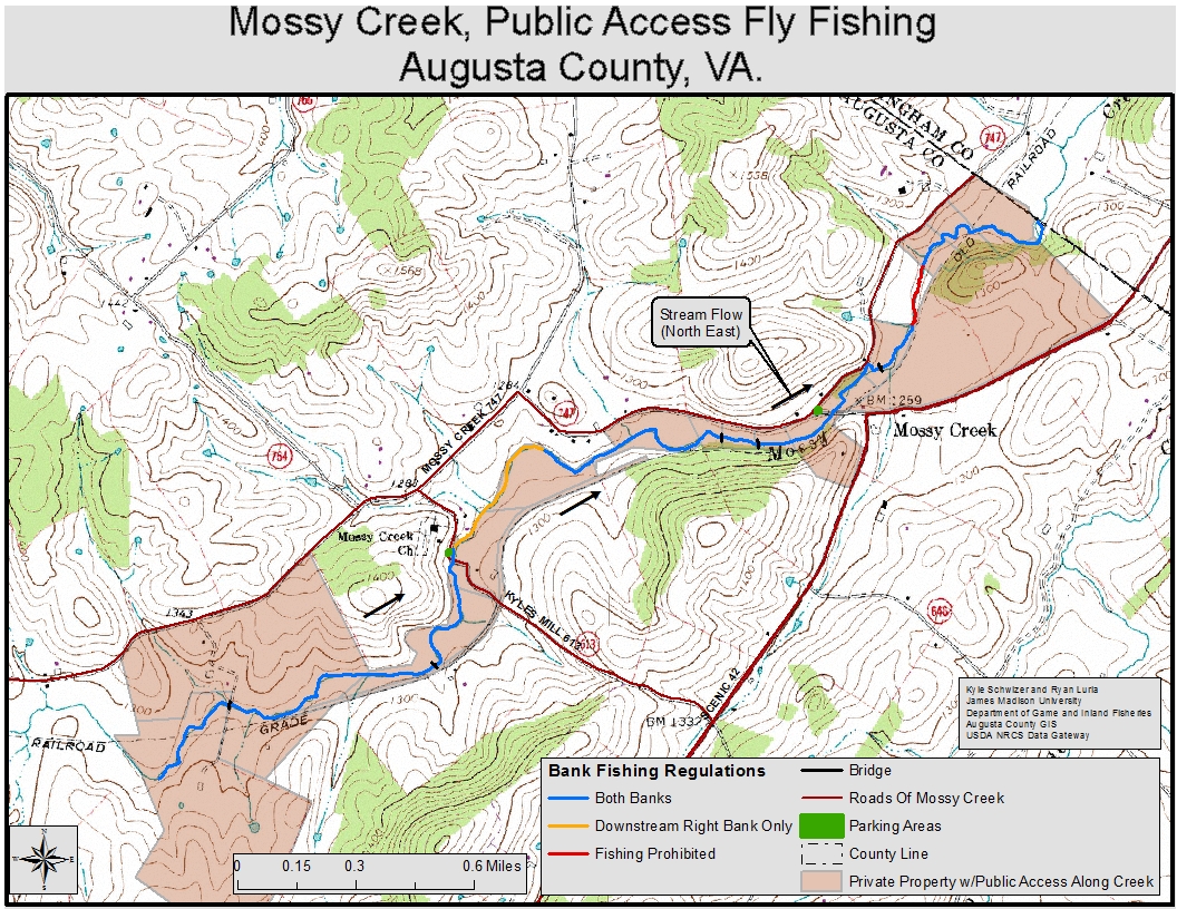
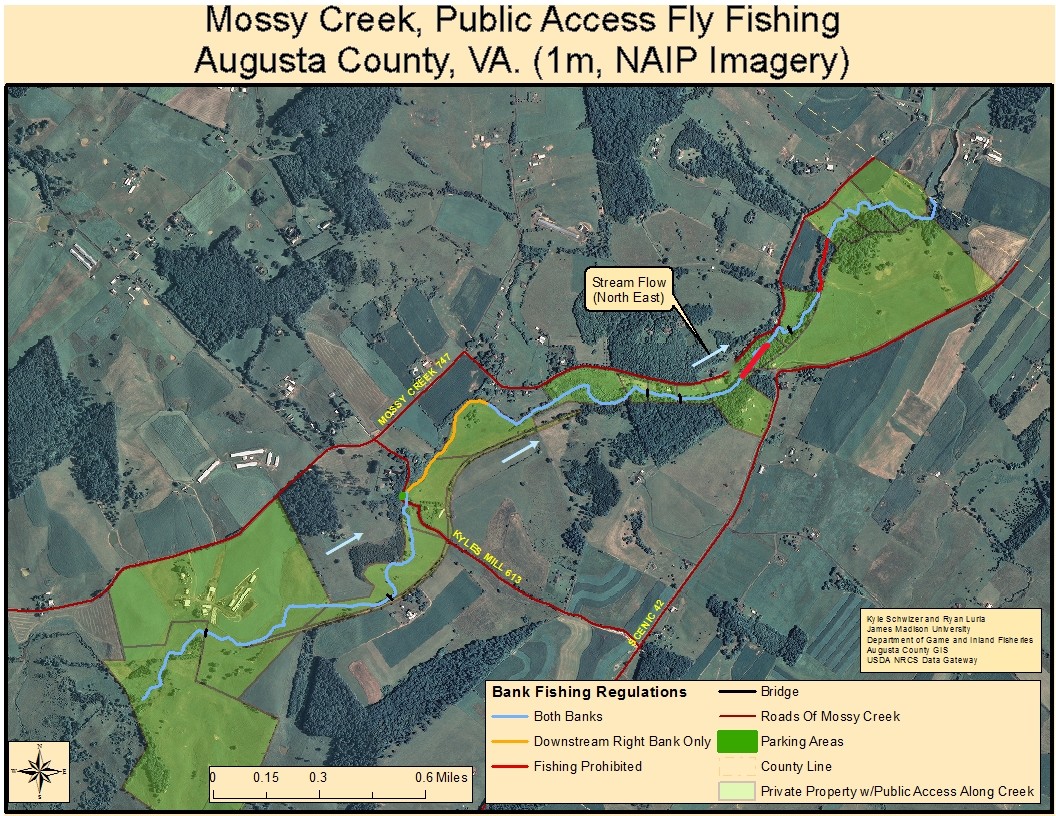
*Mossy Creek (Augusta County):
A 4-mile portion of stream upstream from the Augusta/Rockingham county line to a sign posted at the confluence of Joseph’s Spring. The stream is located just off Route 42 south of Bridgewater. Fishing is restricted to fly-fishing only and *a free written landowner permit is required to fish these waters. A no cost permit can be obtained from DWR’s Go Outdoors Virginia website.
- View a map (indicating stream sections closed to fishing) of the Mossy Creek Special Regulation Area
- View a satellite image version of the map of the Mossy Creek Special Regulation Area
*South River (Augusta County):
That portion of South River from North Oak Lane Bridge in Waynesboro upstream to a sign posted approximately 1.5 miles above the Rt. 626 (Shalom Road) Bridge. This section of stream flows through private property and *a free written landowner permit is required to fish these waters. A no cost permit can be obtained DWR’s Go Outdoors Virginia website.
Catch and Release Only
Beaver Creek (Washington County):
That portion of stream and its tributaries within the boundaries of Sugar Hollow Park in the City of Bristol.
Big Stony Creek (Mountain Fork) (Wise and Scott Counties):
That portion of Big Stony Creek (Mountain Fork) and its tributaries within the Jefferson National Forest from the outlet of High Knob Lake downstream to the confluence of Chimney Rock Fork and Big Stony Creek.
Brumley Creek (Washington County):
That portion of stream and its tributaries from the Hidden Valley WMA boundary upstream to the Hidden Valley Lake Dam. This portion of stream is hike-in access only from the Hidden Valley WMA.
*Dan River (Patrick County):
That portion of stream and its tributaries between the Townes Dam and the Pinnacles Hydroelectric Powerhouse. This section can be reached by taking Route 8 south from Stuart to Route 103 west, turn right on Route 648 at Claudeville, and proceed to the powerhouse at the end of the road. The upper end of this section can be reached by taking Route 614 south from Meadows of Dan, turning left on Route 602, and proceeding to Townes Dam. *A permit from Northbrook Virginia Hydro LLC is required and information about permits can be obtained by calling 276-251-5141.
East Fork Chestnut Creek (Farmers Creek) (Grayson and Carroll Counties):
That portion of stream and its tributaries upstream from the Blue Ridge Parkway. The stream lies south of Galax, crossing the Blue Ridge Parkway a short distance east of Route 89.
Little Stony Creek (Scott County):
That portion of Little Stony Creek and its tributaries within the Jefferson National Forest from the Falls of Little Stony Creek downstream to a posted sign at the Hanging Rock Recreation Area.
Little Tumbling Creek (Smyth and Tazewell Counties):
That portion of stream within the Clinch Mountain WMA. Access is available from Route 91 via a WMA access road that parallels the lower 2 miles of stream. Access to the headwaters is by foot only.
Big Tumbling Creek (Russell, Smyth, and Washington Counties):
Seasonal Catch and Release Only (October 1st until five days prior to the start of the Fee Fishing Season. Closed to angling five days prior to the start of the Fee Fishing Season). That portion of stream located on the Clinch Mountain WMA from a sign starting at the foot of the mountain and extending upstream to the Briar Cove Bridge and also Laurel Bed Creek upstream to Laurel Bed Dam. A trout license is required.
North Creek (Botetourt County):
That portion of stream and its tributaries upstream from a sign at the North Creek Campground.
The stream is located east of Buchanan, a short distance from I-81. The Jefferson National Forest maintains a campground adjacent to the stream and vehicular access is available along most of its length.
North Fork Moormans River (Albemarle County):
That portion of the stream from the head of Sugar Hollow Reservoir upstream to and including the portion within the Shenandoah National Park. Access is available using Rt. 614 past Sugar Hollow Reservoir.
Rapidan River (Madison County):
That portion of stream and its tributaries (including Staunton River) upstream from a sign at the lower Shenandoah National Park boundary (includes the entire stream and its tributaries within the Shenandoah National Park and the Rapidan WMA). Access to the Rapidan is available using Route 662 from Graves Mill and Route 649 from Criglersville.
Redbud Run (Frederick County):
Approximately 1.3 mile section of stream within the Redbud Run WMA starting at Route 656 and ending just downstream of Route 660.
Angler parking is located off of Route 660 just north of Route 7, east of Winchester.
Roaring Fork (Tazewell County):
That portion upstream from the southwest boundary of Beartown Wilderness Area of the Jefferson National Forest. Access can be gained from Forest Service Road 222 off Route 16, south of Tazewell, some hiking will be required.
Smith Creek (Alleghany County):
That portion from the Clifton Forge Dam downstream to a sign at the Forest Service boundary above the C & O Dam. Best stream access is by Route 606 from Clifton Forge to the Clifton Forge Water Plant access road; anglers must park at the entrance and walk a half mile to the stream.
Snake Creek (Carroll County):
That portion of Big Snake Creek below Hall Ford and that portion of Little Snake Creek below the junction of Routes 922 and 674, downstream to Route 58. Fishing downstream of Route 58 is no longer permitted. Parking and angler access is only permitted along Route 922 and at the Route 58 bridge (unless an individual is a landowner or guest).
South Fork Holston River (Smyth County):
That portion of stream from the concrete dam at Buller Fish Hatchery downstream to the lower boundary of the Buller Fish Hatchery. Access can be gained through the Buller Fish Hatchery property off Route 650, south of Marion.
South River (Augusta County/City of Waynesboro):
That portion of stream from the Second St. Bridge upstream 2 miles to the Wayne Ave. Bridge in the City of Waynesboro. A trout license is required.
Spring Run (Bath County):
That portion of the stream from its confluence with the Cowpasture River upstream to a cable and posted sign at the discharge from Coursey Springs Hatchery. Parking is available at the angler access just below the hatchery. A trout license is required October 1 through June 15.
Stewart’s Creek (Carroll County):
Approximately 4.5 miles of Stewart’s Creek and its two major tributaries, North Fork and South Fork Stewart’s Creek, within the Stewarts Creek WMA. Stewart’s Creek WMA is southeast of Galax on the east side of the Blue Ridge Parkway. Take Exit 1 off I-77. Follow the trailblazer signs to the area.
Venrick Run (Wythe County):
That portion of Venrick Run and its tributaries within Big Survey WMA and Town of Wytheville property. The stream can be accessed from a parking lot on Town property at the end of State Route 684, off of State Route 21, south of Wytheville.
Whitetop Laurel/Green Cove Creeks (Washington County):
Whitetop Laurel (2 sections)—that portion upstream from the first railroad trestle above Taylor Valley to the mouth of Green Cove Creek at Creek Junction and that portion upstream from the mouth of Straight Branch to a sign at the Forest Service boundary just downstream of Taylors Valley. There remains a section of catchable stocked trout water without special regulations through the village of Taylors Valley.
Green Cove Creek—that portion from Rt. 859 downstream to its mouth. The special regulation area is located east of Damascus (near the Tennessee line) and lies within the Mount Rogers Recreation Area.
Wolf Creek (Washington County):
That portion of stream and its tributaries within the Abingdon Muster Grounds in the Town of Abingdon from Colonial Avenue downstream to Stone Mill Road.