
Less than 30 miles east of the Chesapeake Bay, Hog Island Wildlife Management Area houses an impressive complex of wetlands along the southern bank of the Lower James River. Hog “Island” is actually an approximately 1,650-acre peninsula that juts into the brackish waters of the James River estuary, creating a mosaic of tidewater habitats that include marshes, tidal channels, beaches, and inland wetland impoundments. This area has long been a mecca for migrating waterfowl, and tens of thousands of ducks and geese still utilize these wetlands each year. Though dominated by wetlands, the peninsula also contains several hundred acres of active farmland and upland forest and maintains stable deer, turkey, dove, and Bobwhite quail populations.
The Virginia Department of Wildlife Resources (DWR) utilizes several management techniques on Hog Island to ensure the area continues to provide ample habitat and food resources for the many species of wildlife that rely on this unique area. Hog Island has a series of low dikes that double as access roads which create eight independent wetland units, otherwise known as impoundments. DWR implements moist-soil management within the impoundments to influence plant growth and provide quality waterfowl habitat. Other management activities include agricultural farming to benefit wildlife, invasive species control, and living shoreline restoration to combat erosion. Read through the sections below to learn more about the different management techniques utilized on the property.
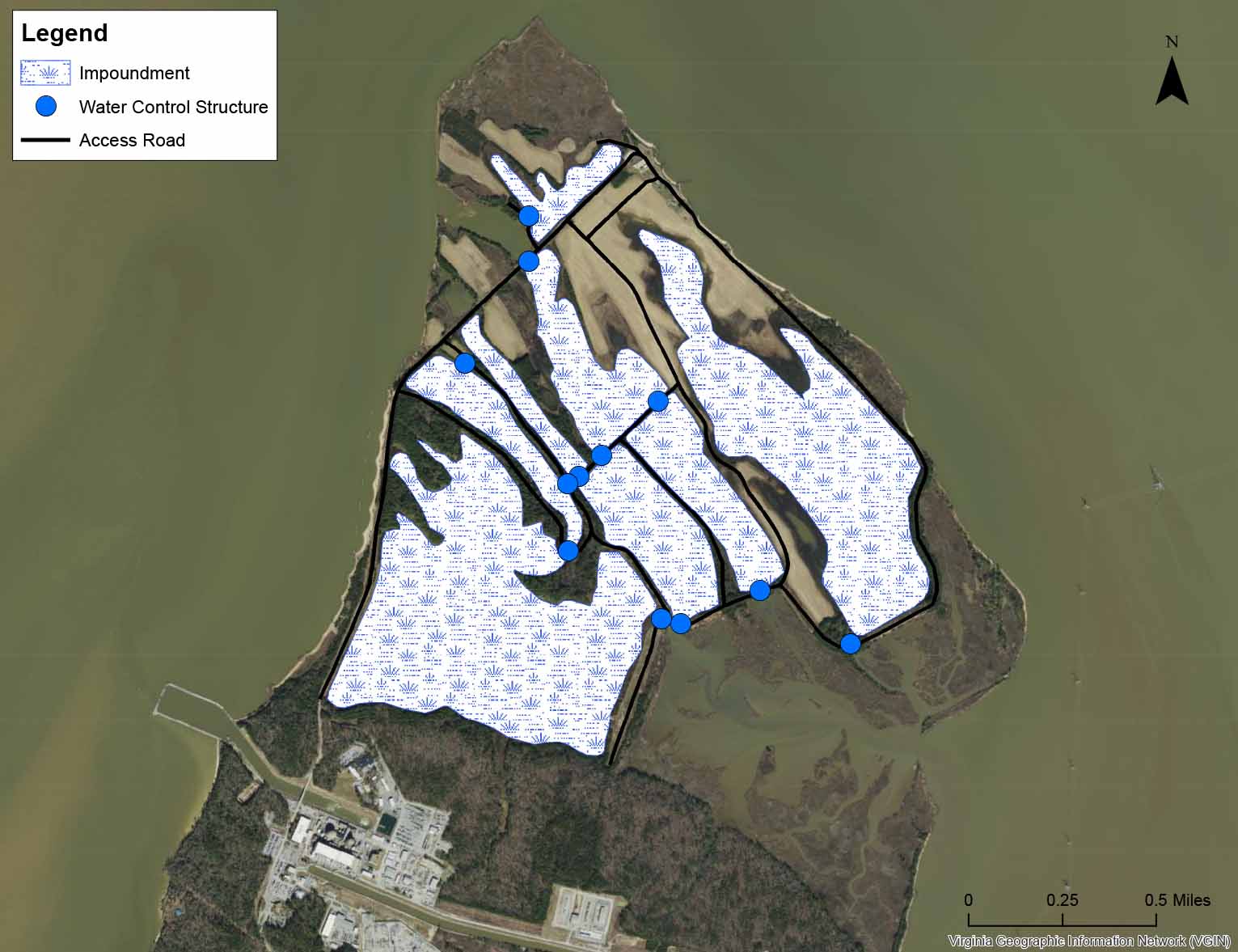
Figure 1: Moist-soil managed wetland impoundments at Hog Island WMA.
Moist-Soil Management at Hog Island
What is Moist-Soil Management?
Moist-soil managementA wildlife management technique where water levels within an impounded wetland are manipulated to influence plant growth by mimicking the flooding and drying cycles in many natural wetlands. is a practice that allows land managers to manipulate water levels so they can mimic natural wetland flooding and drying cycles. This practice ensures the managed wetlands promote the growth of beneficial wetland plants in the spring and summer and provide high-quality wetland habitat through the fall and winter. Generally, moist-soil wetlands do not need to be planted because these frequently flooded areas contain an abundance of native plants like wild millet, wild rice, smartweeds, bulrushes, spikerushes, and submerged aquatic vegetationA rooted aquatic plant that grows completely under water. (SAV). These native plants are particularly favorable because they produce large seeds or have other edible plant parts.
The eight wetland impoundmentsAn enclosed body of water, such as a reservoir, flooded rice/agricultural field, or managed wetland. at Hog Island are surrounded by a low dikeA low dam or wall, often of earthen material and vegetated, that divides or encloses land. or high ground on all sides and have only one or a few controlled locations where water can exit. There are 12 water control structures on the management area which are located along the dikes at the water exit point(s). These water control structures allow DWR staff to manipulate the water level within each impoundment independently of the others. Most of the water control structures at Hog Island contain tidal gates which take advantage of daily and seasonal tidal cycles to flood and drain the wetland units. A gate inside the water control structure can be set to allow water to flow into the impoundment at high tide, but keeps water from flowing out at low tide, effectively raising the impoundment water level (see Figure 3). The gates can also be switched to drain or lower the water levels within the impoundments using the low tide.
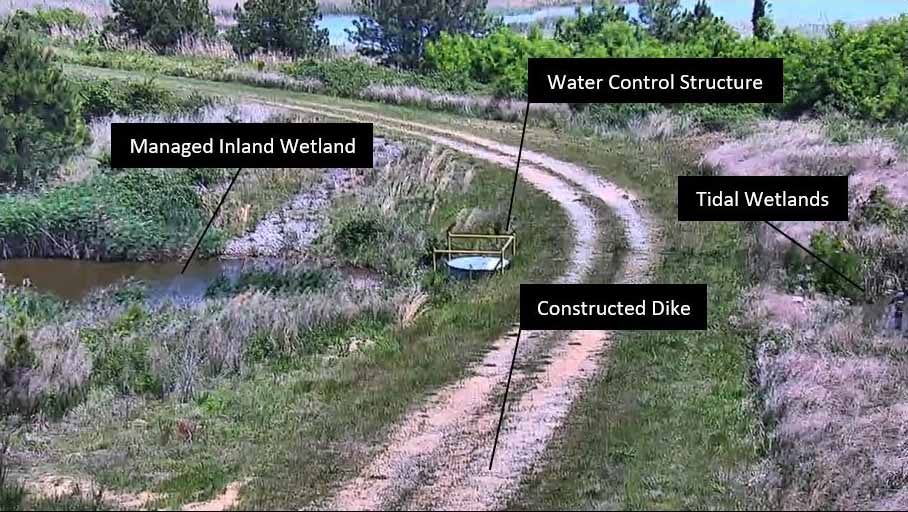
Figure 2: View of a water control structure and a dike to the west of the Marsh Cam.
Figure 3: Diagram of tidal water control structure and human-made dike during the winter. A gate inside the water control structure allows water to flow into the wetland impoundment at high tide, but keeps water from flowing out at low tide.
Drawdown and Flooding Timing
The timing of drawdownIn moist-soil management, the lowering of water levels within an impounded wetland. and flooding in moist-soil impoundments is the key factor to managing these wetlands. Generally, the water level in moist-soil wetlands is “drawn down”, or lowered, in the late spring and summer to encourage plant growth. Drawdowns promote both emergent vegetationA plant that grows in water but which pierces the surface so that it is partially in air. and SAV growth by exposing soils in shallow areas and allowing light to penetrate deeper through areas that hold standing water year round. If these wetland units were permanently flooded they would not be able to support as much vegetative growth. The timing of the drawdown influences which wetland plant species are likely to grow. An early growing season drawdown in April would favor different plant species compared to a late growing season drawdown in August.
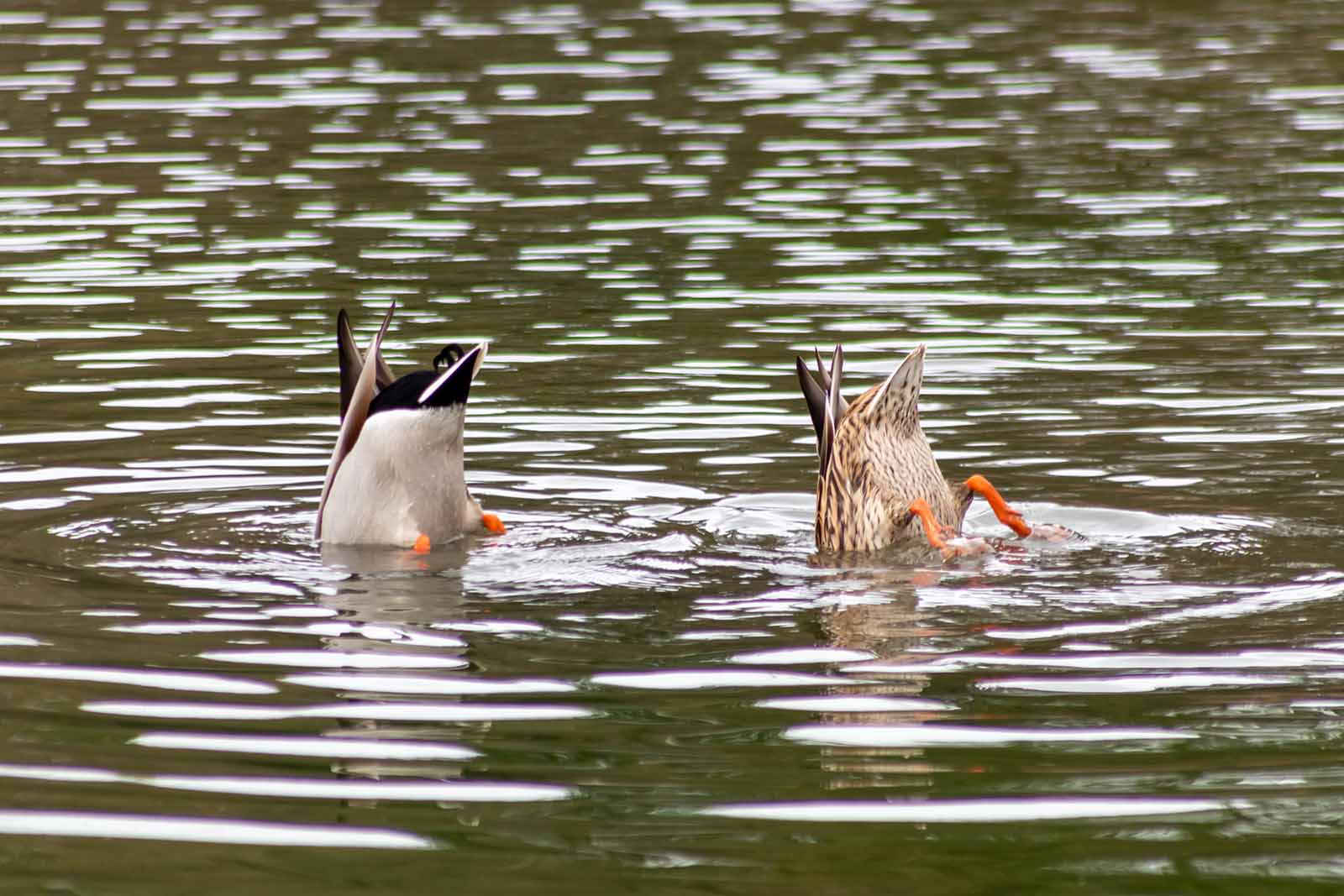
Figure 4: “Dabbling” mallards.
The impoundments are then flooded (i.e. water level is raised) through the fall and winter to provide quality wetland habitat loaded with food for migrating waterfowl and other waterbirds. During the fall and winter, water levels are set so the majority of the wetland impoundment is flooded by 4-18 inches of water. These are ideal conditions for dabbling ducks, like mallards, wood ducks, teal, and gadwall, to easily tip over and enjoy a quick meal. These shallow water conditions also favor other migratory waterbirds including wading birds and shorebirds.
Come spring, preferred food resources for pre-breeding and breeding female ducks, molting ducks, and shorebirds shifts from mostly vegetarian to a diet heavy with aquatic insects and other invertebrates like snails and small crustaceans. Flooded moist-soil wetlands support an abundance of these invertebrates which are essential protein-rich resources required for molting and egg production. Land managers at Hog Island maintain flooded wetland conditions in many of the impoundments through the spring to ensure resting and foraging opportunities are available for waterbirds migrating back north for the spring and summer.
Because there are 8 independent wetland impoundment units at Hog Island, the exact timing of flooding and drawdown is often staggered to increase plant and habitat diversity across the WMA. Variability in the depth of water and in the timing and duration of flooding and drawdown is ideal to provide an array of quality food sources and habitat.
Farming and Upland Management for Wildlife
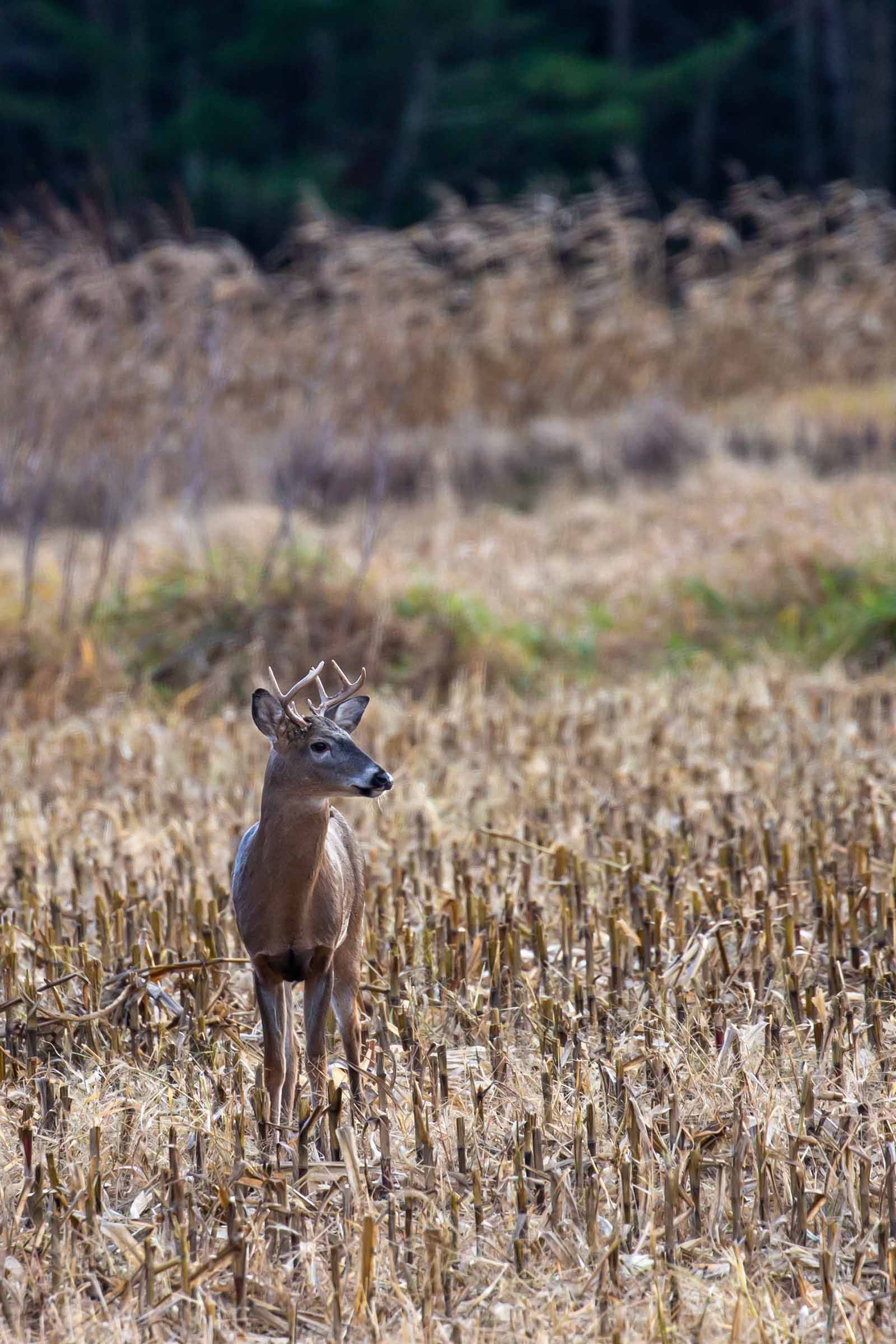
Figure 5. Deer in agricultural field.
The Hog Island peninsula also contains several hundred acres of managed upland habitat. Many of the fields adjacent to the impoundments are managed in agricultural crops. A rotation of corn and soybean is planted, and following harvest, residual grain provides food for migrating waterfowl. Other crops that can provide value to wildlife include millet, wheat, and milo. Having these readily available foods can be especially important during cold snaps. After harvest, these fields are planted with a cover crop (e.g., typically winter wheat) which prevents soil erosion and provides an additional food resource.
Waterfowl are not the only wildlife that benefit from these plantings. Many other species will use these fields. Bobwhite quail can frequently be heard calling, deer munch on leaves, and turkey and dove forage over the exposed soil. The farm fields at Hog Island are a patch work of cultivated areas and native early successional habitat. The native grass and flower meadows diversify the landscape and support pollinators. The remaining uplands at Hog Island include areas of shrubby cover and mature trees. These mature woody areas provide habitat for a great variety of wildlife including many songbirds. The mature tree canopy is utilized as nesting habitat for bald eagles, with as many as 7 active nests located on Hog Island WMA.
Invasive Species Management
Invasive speciesA species that is not native to the ecosystem under consideration and whose introduction causes or is likely to cause economic or environmental harm. are a challenge for habitat managers. Invasive species are those that originate from other parts of the world and have the potential to cause environmental and economic damage. When these species are established in new areas they can take over, crowding out native species and reducing habitat quality.
An invasive species that is especially problematic at Hog Island is the common reed, often referred to by its scientific name, Phragmites. This marsh grass originated in Europe and has no natural controls (e.g., insect herbivores or other pathogens) in North America. Phragmites is aggressive and often crowds out all native vegetation. It spreads and reproduces quickly and can grow up to 20 feet tall. While Phragmities provides dense cover and shoreline stabilization, it has little value to wildlife. It doesn’t provide food and can grow so thick that wildlife is not able to traverse through the marsh. Controlling Phragmites is a challenge at Hog Island. The plant is established on shorelines all along the James River, so seed and other plant parts are constantly being reintroduced. The same habitat management that encourages the growth of valuable native plants (i.e., moist-soil management) can also create excellent growing conditions for Phragmites. To combat this, staff monitor the impoundments to keep track of where Phragmites is growing. Left unchecked, Phragmites would take over more and more of the wetland area at Hog Island.
To maintain the habitat value, DWR utilizes the aerial application of herbicides to control this aggressive and invasive plant. Herbicides are carefully selected and must be legally approved for use in wetland areas. Digital maps are created to ensure herbicides are only applied where they are needed. Spraying only occurs when environmental conditions ensure we can avoid impacting non-target species. DWR specifically targets Phragmites by spraying in the fall when most desirable plants are dormant and by using selective herbicides.
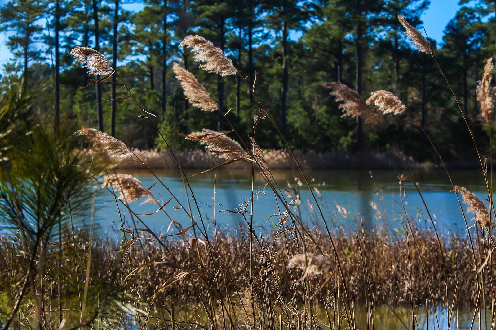
Figure 6: Invasive common reed (Phragmites australis).
Shoreline Erosion Management
Shorelines are dynamic environments which are gradually being affected by rising sea levels and can change drastically following a storm surgeThe abnormal rise in seawater level during a storm, measured as the height of the water above the normal predicted astronomical tide.. The shorelines at Hog Island are particularly vulnerable to loss during a storm surge because of the large fetchFetch is the distance of open water which the wind can blow across. across the James River estuary. Unusually high waters and strong winds blowing across a large fetch can create powerful waves which crash along and erode shorelines. Not only does the loss of shoreline at Hog Island impact existing infrastructure like buildings, roads, and dikes, but lost shorelines also add excess nutrients and sediments to the Chesapeake which increases turbidity and impacts water quality.
Over the past three decades, DWR has been able to implement shoreline stabilization and living shoreline restoration on Hog Island through beach nourishmentThe process of placing additional sediment on a beach or in the nearshore., the installation of near-shore rip-rap breakwatersA human-made hardened structure built out in the water in order to prevent beach erosion or to trap and accumulate sand., constructed tombolosA naturally occurring or constructed narrow sandy piece of land formed by wave refraction and diffraction that connects two areas across an expanse of water by which they are otherwise separated., and beach grass plantings. These features work together to slow down waves, promote sediment accretion, and provide lasting shoreline stabilization.
Hog Island has a long history of implementing shoreline protection. Beach nourishment, or the addition of sediment and sand, stabilized the southwest corner of the property in the early 2000’s. In the early 2010’s, 6 rip-rap breakwaters and tombolos were constructed along western shoreline. In 2021, with help from Ducks Unlimited, the Virginia Department of Conservation and Recreation (DCR), and the Virginia Environmental Endowment - James River Water Quality Improvement Program (VEE JRWQIP), the most recent living shoreline project finalized protection efforts needed along the western shoreline. The project included beach grass and riparian buffer plantings, the construction of 7 new rip-rap breakwaters, and beach nourishment to form tombolos.
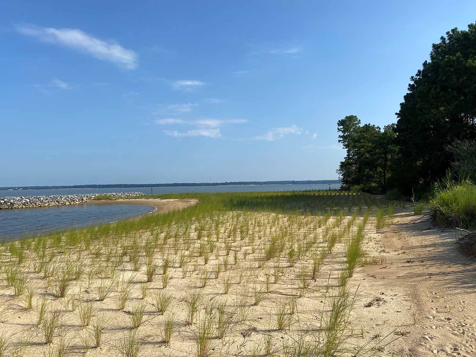
Figure 7: Breakwater, tombolo, and beach grasses recently installed along the western shoreline of Hog Island (2021).
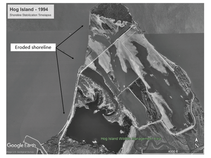
Figure 8: Time-lapse of Hog Island highlighting restoration work performed along the western shoreline.