
Description
Located on a spit of land where the waters of the Chesapeake Bay enter Hampton Roads, the unique and historic area of Fort Monroe makes an excellent destination for wildlife observation with over 200 species of birds documented. Proclaimed a unit of the national park system in 2011, the site is jointly managed, preserved, and interpreted by the Commonwealth of Virginia’s Fort Monroe Authority, the National Park Service, the US Army, and the City of Hampton.
Virginia’s largest seabird breeding colony is located just offshore at the Fort Wool habitat complex, providing opportunity to view a diversity of terns and black skimmers while they forage around Fort Monroe from mid-April through early September. In addition to the breeding colony’s birds, exploring Fort Monroe can be productive for observing osprey, brown pelican, gulls, shorebirds, and wading birds. Winter brings the opportunity to spot northern gannet, loons, and a diversity of waterfowl. Fort Monroe is also known for attracting the occasional exciting rarity/ vagrant bird species. Other popular wildlife observable at Fort Monroe include red fox, bottlenose dolphin, butterflies, dragonflies, jellyfish, and fish.
Fort Monroe contains several vantage points for wildlife observation. Begin your exploration by stopping off at the visitor center to pick up a map of the area. From there, explore the various wildlife viewing highlights below. You may also want to allow extra time to visit the Fort Monroe National Monument, the Fort Monroe Visitor and Education Center, the Casemate Museum, and other historical points of interest to learn the area’s rich history.
Wildlife Viewing Spots and Highlights:
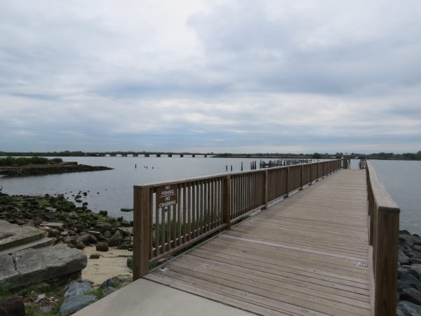
- Fort Monroe Seawall – The primary attraction for birders at Fort Monroe is the Seawall, a paved, public walkway that wraps all along Fort Monroe’s waterfront, providing a view of the Chesapeake Bay and Fort Wool. The western portion of the Seawall is a particularly popular area for birding, but a couple of piers along the walkway and Outlook Beach provide additional vantage points. Several public parking areas along the Seawall are available to aid your exploration. A variety of seabirds may be observed, including all of the species breeding at the Fort Wool habitat complex: royal tern, common tern, the state-threatened gull-billed tern, laughing gull, and black skimmer. Osprey, American oystercatcher, and bottlenose dolphin may also be spotted. In winter months, look for a wide diversity of overwintering waterfowl and northern gannet.
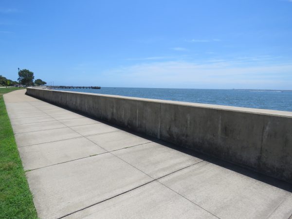
The Seawall walkway with one of the piers in the background.
- The Moat Surrounding the Fort – The moat is easily viewed from the following access points: a footbridge that leads into the fort (known as the Postern Gate) located behind the Fort Monroe Visitor and Education Center; a paved path known as the Moat Walk that encircles the outer perimeter of the Moat; or the three vehicular gates and bridges accessing the fort on the West, East, and North sides. Wildlife observable in and around the moat include egrets, osprey, wintering waterfowl, and jellyfish.
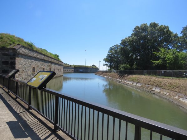
The moat viewed from the main gate behind the visitor center.
- Parade Ground –This open area contains many mature live oak trees that provide habitat for songbirds and cooper’s hawks. It’s also a good area to spot red fox. While here, be sure to check out the 500-year-old “Algernourne Oak,” a champion tree, which is located on the far eastern side of the Parade Ground, near the east gate. Access points to the parade ground include the Postern Gate (the footbridge behind the visitor center) as well as the main, north, and, east gates.
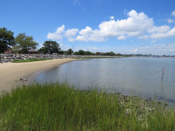
- Rock Jetty at Outlook Beach – The beachfront at the northern end of Outlook Beach, near the rock jetty, provides a good spot to look for seabirds, wintering waterfowl, and shorebirds that may be foraging near the rocks. Visitors are asked to stay off the rocks found at Fort Monroe for safety.
- Wildlife Observation Platform – A wildlife observation platform is located at the far northern end of Fort Monroe. Visitors may park at a pulloff at the end of Fenwick Road and walk a paved concrete road (open to foot traffic only) through a managed meadow habitat, which leads toward the observation platform. An unmaintained footpath through tall grass leads to the observation platform, which overlooks Mill Creek, a tributary to the Chesapeake Bay. Look for bottlenose dolphin, osprey, black skimmer, and brown pelican. Swallows, killdeer, eastern meadowlark, dragonflies, and butterflies may be seen around the managed meadow. The area is also another spot to look for Fort Monroe’s red foxes. (Please note, the observation platform does not undergo regular maintenance and is to be used at your own risk.)
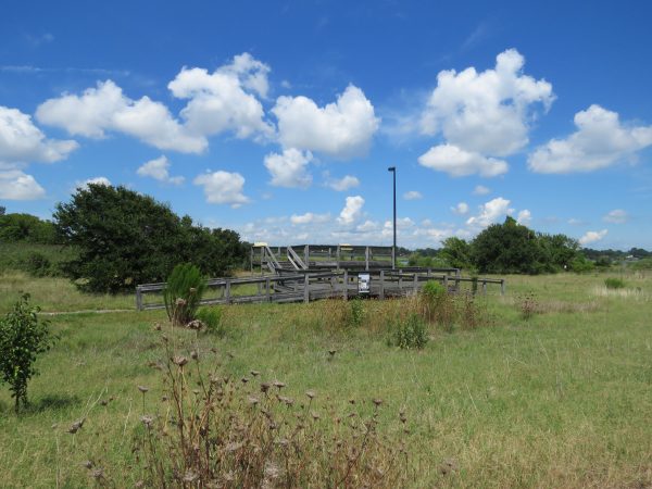
The wildlife observation platform at Fort Monroe’s northern end overlooks Mill Creek.
- Kayak Launch – Located off Stilwell Rd with parking available, this launch provides a spot to launch a kayak or canoe onto Mill Creek for birding and wildlife viewing on the water. It’s a good spot to look for osprey nests, black skimmers, brown pelicans, wading birds, wintering waterfowl, fish, and crabs. An oyster bed is visible at low tide.
View of the Mill Creek shoreline from the kayak launch.
- Phoebus Pier/Phoebus Waterfront Park – Referred to locally as the “dingy dock,” this public pier off East Mellon Street makes for an easy stop on your way into or while leaving Fort Monroe. Brown pelicans and other seabirds are often visible perched on the pilings. Wading birds may be observed along the shoreline.
The pier (“dingy dock”) at Phoebus Waterfront Park
Visitation Notes:
- Restrooms are available at the Visitor and Education Center and the Casemate Museum. Be sure to check ahead for their hours of operation. Alternatively, there are portable toilet facilities, available seasonally, along the Seawall and adjacent to the Chamberlin.
- Public parking is available throughout Fort Monroe. Please use designated public parking areas. Do not park on the grass. Parking at the Chamberlin is only for residents and guests of the Chamberlin, but there is plenty of nearby public parking available.
- Do not approach the wildlife. Maintain a safe, respectful distance at all times. If your presence causes the wildlife to move or impacts their behavior please move further away.
- Do not go past the fence that is north of the wildlife observation platform. This area is off limits to the public.
- Fort Monroe can be a busy place during the summer season. To avoid the crowds at this time of year, it is recommended to visit early in the morning. Additionally, it is recommended to avoid traveling into or exiting Fort Monroe during rush hour due to the heavy traffic conditions on the Hampton Roads Bridge-Tunnel. If travelling to/ from the area during rush hour times, use of Mercury Blvd is recommended.
- Any group (20 or more individuals) wishing to visit Fort Monroe should inquire with the Fort Monroe Authority before visiting. Activities including wildlife and other nature related tours often require permits and additional information. Please contact the Fort Monroe Authority Special Events Department for permit information by calling 757-637-7778.
Historical Notes:
The land that present-day Fort Monroe resides on was inhabited by Indigenous People for centuries before the arrival of the first English and first Africans in the early 17th century. The area provided bountiful sustenance to the Kecoughtan Indians, members of the Algonquin speaking people, who used it for their summer hunting and fishing grounds. After the destruction of the Kecoughtan village by the colonists, in present-day Hampton, survivors were assimilated into other tribes, most likely the Pamunkey and Mattaponi. The English occupied what was then called Point Comfort, erecting forts and using the spit of land for coastal defense. This is also the site of the landing of the first enslaved Africans to the Virginia Colony, who arrived after the torturous middle-passage from the Kingdom of Ndongo, (present day Republic of Angola.) Throughout the subsequent centuries the landscape changed little.
The first permanent structure to be built was the lighthouse in 1802 to warn ships off its shore. After the War of 1812, Fort Monroe became the first, and largest masonry fort built during the Third Fort System of Defense. Begun in 1819 and completed in 1834, Fort Monroe is the largest masonry fortification constructed in the United States and the Western Hemisphere. Over time, the fort has been constantly adapted and reutilized as the needs of the nation’s defenses changed. Home to the Artillery School of Practice and later the Coast Artillery Training School, numerous soldiers and their families occupied the houses and billets transforming Fort Monroe into a small town unto itself.
War periodically interrupted the ebb and flow of daily life and the landscape of the site. It was held by the Union Army during the American Civil War where its soldiers witnessed the Battle of Hampton Roads from atop the fort walls. It also became known as “Freedom’s Fortress” as tens of thousands of freedom seekers arrived following the 1861 “Contraband Decision.”
Throughout the remaining 19th and 20th centuries the fort’s footprint physically expanded time and again through aggressive land fill projects. The marsh, access to deep water, and its almost-island-like feel provides ample opportunities for all to enjoy Fort Monroe.
Wildlife Sightings
236 species have been reported at this site to date.
Birds Recently Seen at Fort Monroe:
- Canada Goose
- Mourning Dove
- Laughing Gull
- Ring-billed Gull
- American Herring Gull
- Royal Tern
- Double-crested Cormorant
- American Crow
- European Starling
- Brown-headed Cowbird
Recent Checklists:
| Date | # of Species | Submitted By |
|---|---|---|
| 16 Mar 2026 | 10 | Jennifer and Scott Martin |
| 15 Mar 2026 | 3 | Louis Sokolow |
| 15 Mar 2026 | 8 | Grant Kirchhoff |
| 15 Mar 2026 | 30 | Niklas Hallberg |
| 15 Mar 2026 | 39 | Judy Jones |
Amenities & Accessibility
Amenities
- On-site Parking
- Restrooms
- Birdability Report Available
Other Amenities: Camping/Lodging, Hiking Trails, Visitor/Nature Center, Historical Site
Accessibility Considerations
This location has a Birdability Site Review available
Learn more about Birdability’s efforts to map accessible outdoor spaces
Maps & Directions
Physical Address: Fort Monroe Visitor and Education Center, 30 Ingalls Rd, Fort Monroe, VA 23651
To the Fort Monroe Visitor and Education Center:
From I-64 in Hampton, take exit 268 for Mallory St toward VA-169 E/Ft Monroe. Turn left onto S Mallory St and continue 0.3 miles. Turn right onto E Mellen St and travel 0.7 miles, then continuing onto Ingalls Rd. Travel 0.6 miles to the Fort Monroe Visitor and Education Center. The Visitor Center will be on the left. A parking lot is available behind the building and street parking is available on the right.
Site Information
Managed By:
- National Park Service
Access Requirements:
- Free, Grounds Open Daily, Sunrise to Sunset. Visitor and Education Center open Wed – Sun 9:30am-4:30pm. Casemate Museum open Wed-Sun 10:00am – 4:00pm.
Contact Information:
- Fort Monroe Authority: 757-690-8181, visit@fortmonroe.org or National Park Service: 757-722-FORT(3678), FOMR_Interpretation@nps.gov
- Visit Website
Sites, or portions of sites, can be closed periodically for management activities. Please always check the site’s website for additional information prior to visiting.