
Virginia’s Wildlife Corridor Action Plan is the result of a cooperative effort between the Virginia Department of Wildlife Resources, Virginia Department of Conservation and Recreation, Virginia Department of Transportation, and the Virginia Department of Forestry.
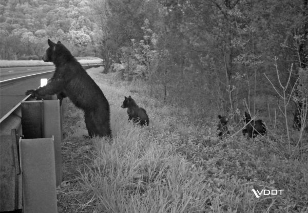
Photo courtesy VDOT.
Virginia is one of the first states in the eastern U.S. to create a Wildlife Corridor Action Plan (Plan) with a clear emphasis on protecting vital wildlife habitat corridors and reducing wildlife-vehicle conflicts, such as collisions, to promote driver safety. Wildlife corridors connect fragmented habitats separated by human activities or infrastructure; this habitat connectivity is vital to the long-term sustainability of wildlife biodiversity. When road infrastructure fragments wildlife habitats, some species of wildlife may need to move across roads to reach suitable habitats for fulfilling their food, water, shelter, and mating requirements. Wildlife-vehicle conflicts can occur, resulting in driver safety risks due to direct collisions with the animals or crashes from avoidance maneuvers, as well as wildlife population impacts such as significant mortality and barriers to dispersal. More than 60,000 known deer-vehicle collisions have occurred annually in Virginia since 2015, costing the Commonwealth and its citizens approximately $533 million each year.
To make roads safer for drivers and wildlife, wildlife crash countermeasures are more frequently being integrated into road transportation projects across the nation. For example, one measure is called a wildlife crossing, which is typically a road underpass or overpass specifically designed so wildlife can cross under or over a road. Benefits of integrating wildlife crash countermeasures into roads include safe wildlife passage, wildlife biodiversity resilience, improved driver safety, and reduced costs.
To create this Wildlife Corridor Action Plan for the Commonwealth, the Virginia General Assembly enacted § 29.1-578 and § 29.1-579 to establish a collaborative leadership team comprised of the Virginia Department of Wildlife Resources, the Virginia Department of Transportation, the Virginia Department of Conservation and Recreation, and the Virginia Department of Forestry. Pursuant to § 29.1-579, the intentions of this legislation for a Wildlife Corridor Action Plan are as follows:
- Intent #1: Identify wildlife habitat corridors comprised of high quality habitats for priority species and ecosystem health using the best available data;
- Intent #2: Identify existing or planned human barriers to wildlife movement along such corridors;
- Intent #3: Identify areas of high risk for wildlife-vehicle conflicts;
- Intent #4: Prioritize and recommend wildlife crossing projects intended to promote driver safety and wildlife habitat connectivity;
- Intent #5: Provide a public portal to host this Plan, data, and maps; and
- Intent #6: Update this Plan every four years.
Based on these intents, the leadership team developed a conceptual framework for this first Plan iteration centered on the following three themes:
- Promote Driver Safety
- Improve Wildlife Corridor Connectivity
- Advance Mutual Benefits
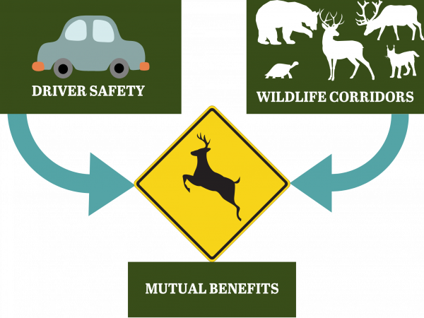
Objectives, products, and opportunities were then designed, developed, and identified, respectively, to align with these themes (see figure below).
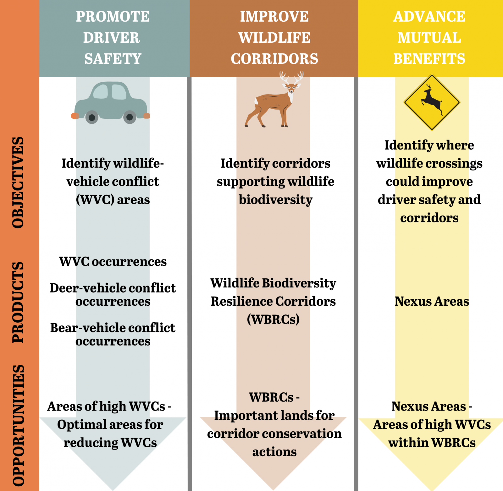
Promoting Driver Safety
To identify road segments experiencing high occurrences of wildlife-vehicle conflicts (see below figure), a geospatial analysis was performed using a subset of data from two databases, Virginia Roads and Virginia Smart Roads. These data collectively offer the most comprehensive statewide data on wildlife-vehicle conflicts that are currently available for Virginia. The data are particularly relevant for collisions with white-tailed deer and black bear, due to how these two species are associated with more costly and injurious collisions for drivers.
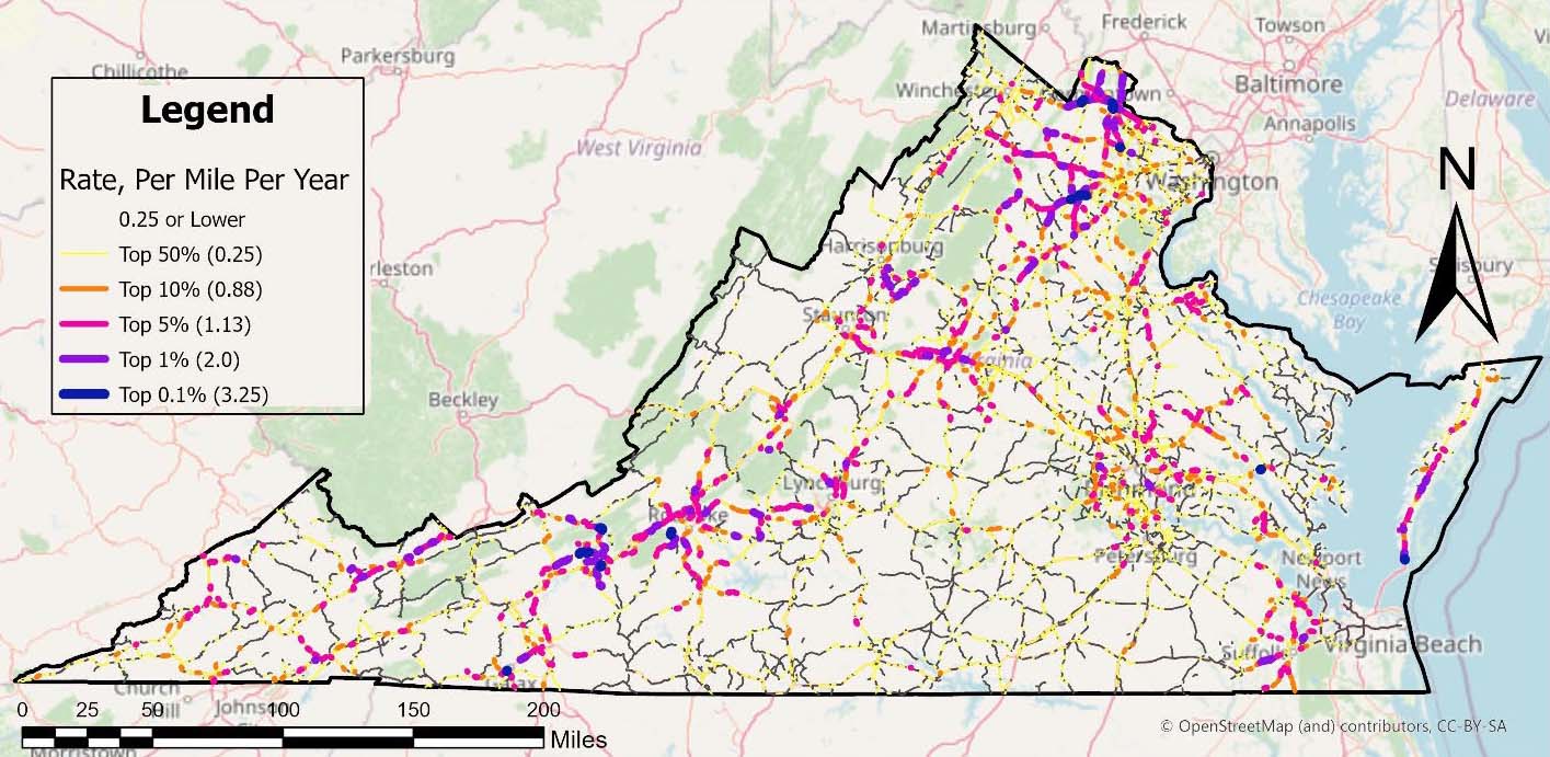
Reported wildlife-vehicle occurrence rates per one-mile road segments.
This Plan acknowledges the following about wildlife-vehicle conflicts and driver safety:
- This Plan defines Areas of High Wildlife-Vehicle Conflicts as important areas to further evaluate for whether wildlife crash countermeasures are warranted for driver safety.
- Potential wildlife crash countermeasures discussed in this Plan include wildlife crossings (such as enhancing existing underpasses), wildlife advisory messages on Changeable Message Signs, and animal detection driver warning systems.
- The Plan encourages, but does not require, consideration of countermeasures early in the transportation planning process for specific types of projects such as the construction of new roads, widening or significant realignment of existing roadways, and bridge and culvert replacements.
- The Plan acknowledges the need for additional monitoring data of wildlife crash countermeasures to assess effectiveness and inform cost-benefit analyses.
- Future updates to the Plan will incorporate a road risk predictability model to identify segments of roads that are at the highest risk of large mammal collisions.
Improving Wildlife Corridors
Leveraging the Commonwealth’s Conserve Virginia and Virginia Natural Landscape Assessment conservation planning tools, as well as other data sources, high priority wildlife corridors were identified and designated as the state’s Wildlife Biodiversity Resilience Corridors (see below figure).

Wildlife Biodiversity Resilience Corridors are comprised of high quality habitats supporting native biodiversity.
The Plan acknowledges the following about improving wildlife corridors:
- For the Wildlife Biodiversity Resilience Corridors, further assessment could identify opportunities for conserving, enhancing, and restoring connectivity within these important wildlife corridors, through actions such as land protection strategies, habitat restoration, and wildlife crash countermeasures along roads.
- These Wildlife Biodiversity Resilience Corridors likely do not fully represent all habitat corridors that may be important to specific federally-protected species, state-protected species, and Species of Greatest Conservation Need, as well as for other species of interest.
- Although these statewide wildlife corridors are providing benefits to aquatic resources, a future analysis is needed to identify barriers to aquatic organism passage for identifying aquatic corridor connectivity priorities. Future enhancements to barriers, such as stream culverts, could provide multiple benefits for aquatic organisms, wildlife, and driver safety.
Advancing Mutual Benefits
By spatially overlaying the Areas of High Wildlife-Vehicle Conflicts and the Wildlife Biodiversity Resilience Corridors, 26 Nexus Areas were identified (see figure below); these Nexus Areas are coarse scale (25 square-mile areas), and, importantly, they represent opportunities where wildlife crash countermeasures could provide both driver safety and wildlife corridor conservation benefits.
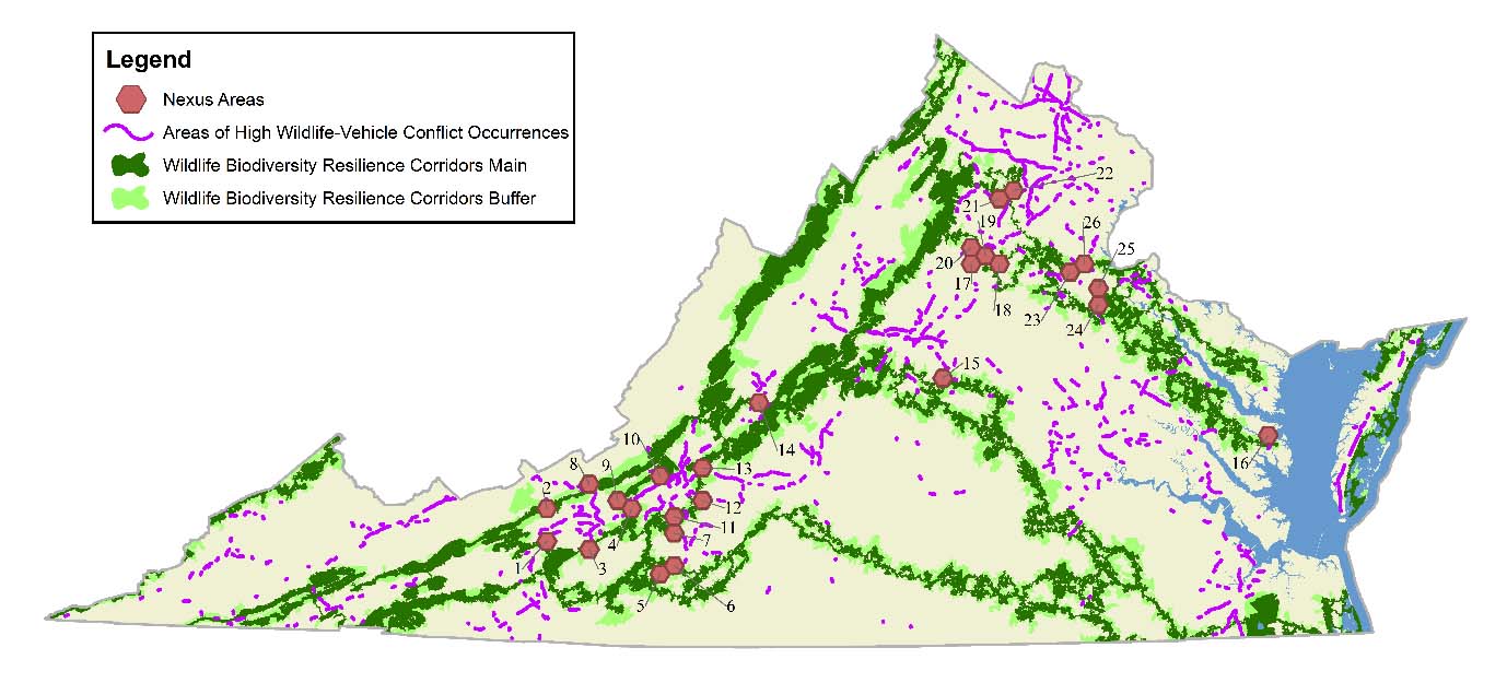
Nexus Areas may be opportunities where wildlife crossing enhancements could improve both driver safety and wildlife corridors.
The Plan acknowledges the following about advancing mutual benefits in relation to these Nexus Areas:
- The Nexus Areas may be particularly important opportunities for seeking competitive federal grant funds, such as under the Wildlife Crossings Pilot Program of the Infrastructure Investment and Jobs Act, which prioritizes proposed projects that will both reduce wildlife-vehicle collisions and improve wildlife corridors.
- Site-specific assessments within the Nexus Areas are required to target the specific road sites that are problematic. Additional field data collection (such as wildlife camera or movement studies, collection of route-specific police report or carcass removal data, or an inventory of existing culverts and bridges) will be required to determine if wildlife crash countermeasures are warranted. Feasibility studies then may be required to assess the practicality for implementing countermeasures such as wildlife crossings.
- Due to the likelihood of limited funding opportunities, a process needs to be developed to prioritize countermeasure projects.
- Given that updating this Plan will be an iterative process as new data and information become available, these Nexus Areas could be refined over time. Additional road sites may also be identified as important opportunities for wildlife crossing enhancements.
Recommendations for Future Actions
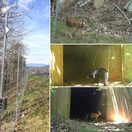
Photo courtesy Bridget Donaldson, Virginia Transportation Research Council
To realize a vision of safer roads for wildlife and for people, the Wildlife Corridor Action Plan leadership team recommends the following 15 actions to refine and implement this Plan, organized by the intentions of the legislation:
Intent #1: Identify Wildlife Corridors
- Identify at-risk terrestrial and aquatic species and other species of interest not sufficiently addressed by the Wildlife Biodiversity Resilience Corridors.
- Identify important habitat corridors for these at-risk terrestrial and aquatic species and other species of interest.
Intent #2: Identify Human Barriers to Wildlife Movement
- For aquatic corridor connectivity, conduct analyses to identify road-associated infrastructure and other types of human barriers impeding aquatic organism passage.
- For the Wildlife Biodiversity Resilience Corridors, identify and analyze non-road barriers (e.g., land uses) impacting corridor connectivity.
Intent #3: Identify Wildlife-Vehicle Conflict Areas
- Improve and standardize road data collection methods for wildlife-vehicle conflicts and wildlife carcasses.
- For at-risk species and other species of interest, identify wildlife crossing concern areas.
- Develop predictive models to identify site-specific road segments at high risk of deer- and bear-vehicle collisions.
Intent #4: Prioritize Wildlife Crossing Projects
- Develop step-down or companion plans, tiering off this Plan, to fully address the habitat corridor and wildlife crossing needs for at-risk species and other species of interest.
- For Areas of High Wildlife-Vehicle Conflict Occurrences, further evaluation is required to identify specific sites where wildlife crossing enhancement projects are warranted and will be feasible.
- For Wildlife Biodiversity Resilience Corridors, evaluate further to identify specific areas that are priorities for land protection, habitat restoration, and/or wildlife crossings to support wildlife corridor connectivity.
- For Nexus Areas, develop a process on how to prioritize wildlife crossing enhancement projects for limited funding opportunities.
- Develop cost-benefit analyses and valuing of wildlife crossings.
- Develop a framework for regional-level and local-level analyses and where efforts to establish targeted partnerships should be focused to identify project opportunities.
Intent #5: Provide a Public Data Portal
- To support planning at multiple spatial scales (e.g., state, regional, and local), develop a geospatial viewer application that is inclusive of relevant planning data that are spatially scalable.
Intent #6: Update Plan Every Four Years
- Establish state interagency and external coordination to ensure progress on updating and implementing this Plan.
This first Plan iteration offers conservation and transportation planners a foundation for how to jointly prioritize wildlife corridor conservation efforts with wildlife-vehicle conflict reduction measures. Although data gaps and challenges remain, the Commonwealth of Virginia now has established a strong basis to strategically direct state and federal resources for the mutually compatible benefits of promoting driver safety and improving wildlife corridor connectivity.
View the Virginia Wildlife Corridor Action Plan
Data
- View the final data here: Natural Heritage Data Explorer
- Download the final data for use in desktop GIS
- Access Wildlife Information and Data here:
- Access all Wildlife-Vehicle Crash data for download here: VDOT Data Portal