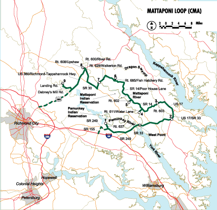
Sites On This Loop
- CMA01: The Nature Conservancy’s Vandell Preserve at Cumberland Marsh
- CMA02: Glenns Campus, Rappahannock Community College
- CMA03: Friends of Dragon Run Teta Kain Nature Preserve
- CMA04: Waterfence Landing
- CMA05: Melrose Landing
- CMA06: King and Queen Fish Cultural Station
- CMA07: Walkerton Landing
- CMA08: Zoar State Forest
- CMA09: Dabney’s Mill Landing, King William County
Description
The Mattaponi Loop offers a transition from the upland woods and river rapids of the Richmond Loop to the marsh locations of Mathews and Gloucester. Pine-oak forest communities dominate this rural area and are interspersed with farmland and freshwater tidal rivers. The loop features stops along the mighty rivers that divide Virginia’s western shore. A variety of wildlife can readily be seen along these waterways, including a myriad of waterfowl, nesting ospreys, and majestic bald eagles. The loop route guides visitors to pristine bald cypress-dominated bottomland forests where interesting reptiles, amphibians, and songbirds reside. The loop continues through the deciduous upland forest typical of the Middle Peninsula interior.
Loop Map

Services
Gloucester County Chamber of Commerce
804.693.2425
gccc@inna.net
New Kent Chamber of Commerce
804.932.9614
mdaniel445@aol.com
River Country Tourism Council
804.843.4499
hrsherwood@aol.com
Tappahannock-Essex Chamber of Commerce
804.443.5241
llumpkin@crosslink.net
West Point/Tri-Rivers Chamber of Commerce
804.843.4620
chamber@westpointva.com

