Sites On This Loop
- CMT01: Piankatank River Landing
- CMT02: South Haven Beach
- CMT03: North Haven Beach
- CMT04: Bethel Beach Natural Area Preserve
- CMT05: Winter Harbor Landing
- CMT06: Horn Harbor Landing
- CMT07: New Point Wharf – This site has been withdrawn from the VBWT
- CMT08: New Point Comfort Natural Area Preserve
- CMT09: Mobjack Bay – This site has been withdrawn from the VBWT
Description
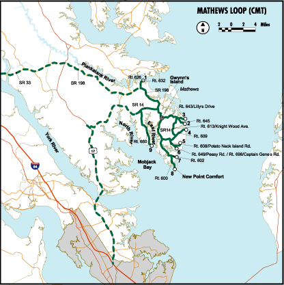
The Mathews Loop visits nine locations along the peninsula that juts eastward into the Chesapeake Bay between the North and Piankatank Rivers. The sites are united by their brackish waters, a result of their proximity to the Chesapeake Bay, but wind and water movements dictate other major differences. Some sites boast clean, white sand where rare tiger beetles hunt minute creatures and shorebirds attack tiny amphipod crustaceans in receding waves. Emerald green marsh grasses border other sites where seaside sparrows buzz and glossy ibises probe for worms and shrimp in rich, black mud. Most of the sites provide views of open bay waters. During winter, a spotting scope will serve visitors well in maximizing viewing opportunities. During migration, shorebirds fill the tidal lagoons, and land birds move along the peninsula’s wooded fringe. Many of the sites have boat launches where a canoe or kayak may be slipped into a quiet channel for a water exploration of the land and sea interface. This loop is dedicated to Mary Watt Pulley, credited with the first recorded sighting of a frigatebird in Maryland. Mary joined the Mathews County Audubon Christmas Bird Count in 1970 and has participated on all 32 counts since that time. She has compiled a life list of 521 birds, at least 300 of which were sited in Virginia. Mary is a shining example of a citizen-scientist who recognizes the importance of collecting data for monitoring bird populations over time.
Loop Map

Services
Mathews County Chamber of Commerce
804.725.9029
mchamber@crosslink.net
Mathews County Visitor & Information Center
804.725.4BAY
mcvic@visitmathews.com

