
The Main Stem Shenandoah River is formed when the North Fork and South Fork converge at Front Royal, Virginia. The Shenandoah flows for 57 miles until it empties into the Potomac River at Harpers Ferry, West Virginia. The section of the Shenandoah which will be discussed is the 35 miles of river that lies within the state of Virginia. The section of the Shenandoah flowing through Clarke County is designated as a state scenic river. The Main Stem Shenandoah is a sixth order stream and averages around 150 feet in width.
The Shenandoah is typically a low gradient river, but there are some class I rapids produced at riffle areas. The substrate of the river varies from bedrock and boulders to cobble and gravel. Several species of rooted aquatic vegetation are found in the shallower regions of the river. This vegetation can become quite dense during the summer months. There is one dam located on the Main Stem Shenandoah River. Warren Dam, which is located immediately downstream of Front Royal, Virginia, is operated as a hydroelectric facility by Allegheny Power. Except for four access points, owned by the Virginia Department of Wildlife resources (VDWR), the riparian area along the entire Shenandoah River is privately owned.
Maps & Directions
Riverton to Morgan’s Ford Map
Distance: 13 miles
Put in at DWR ramp located off of Rt. 340 beside the bridge over the North Fork in Front Royal. Takeout at DWR ramp at Morgan’s Ford on the right by the low-water bridge (Rt. 642). This section of the river is slow-moving and deep, producing quality catfish, bluegill, largemouth bass and carp fishing. A dam four miles downstream requires a portage. Takeout allows rough trailer access, although a canoe is recommended for this float due to the portage.
Morgan’s Ford to Farms Riverview Landing Map
Distance: 4.75 miles
Put in at VDWR ramp beside the bridge on Rt. 624. Canoes and limited trailer access is available at this ramp. Takeout is on the right at the Farms Riverview Landing concrete ramp. Offers excellent fishing for smallmouth, sunfish, channel catfish as well as muskellunge and walleye. Canoeists of all experience levels should enjoy this float.
Farms Riverview Landing to Berry’s Ferry Map
Distance: 6.25 miles
Put in is on Farms Riverview Road, off Myers Drive, which is off of Howellsville road (Rt. 638). Takeout is under the Rt. 50 bridge at the VDWR concrete launch on the left side of the river. This is a 6.25 mile float with a fairly even mix of riffles, runs and pools. It offers excellent fishing for smallmouth, sunfish, channel catfish as well as muskellunge and walleye. Canoeists of all experience levels should enjoy this float.
Berry’s Ferry to Lockes Map
Distance: 10 miles
Put in under the Rt. 50 bridge east of Winchester. Takeout on left at Lockes, Rt. 621. Both VDWR sites offer concrete ramps for canoe or trailer launching. Numerous small riffles and Class I rapids combined with an abundance of aquatic vegetation offer spectacular angling opportunities. This section boasts one of several Indian fish trap remnants found on the river system.
Lockes to Castleman’s Ferry Map
Distance: 5 miles
Put in at ramp Rt. 608 in Clarke County. Take out at the Rt. 7 low-water bridge. Both VDWR access sites offer concrete ramps for canoe or trailer launching, This section has numerous riffles and Class I rapids. Lots of rock cover adds to the smallmouth fishing. Bluegills are also plentiful in this section.
Fishing
Smallmouth Bass
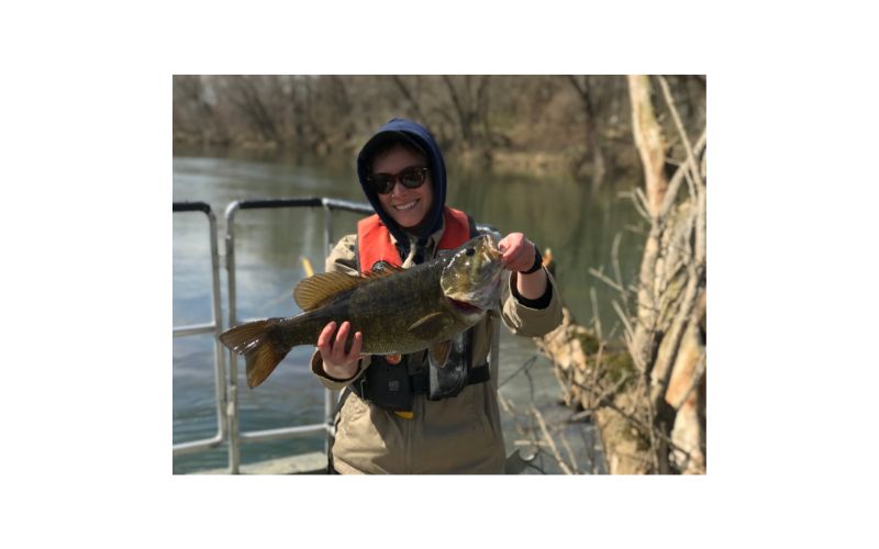
Serious smallmouth anglers know the Shenandoah River is one of the top smallmouth bass rivers in the eastern United States. Densities of smallmouth are not as high in the Main Stem as they are in the North and South Forks of the Shenandoah. Smallmouth bass catch rates can average up to two fish per hour. Fisheries biologists consider catch rates greater than one fish per hour to be very good. Remember, fishing success can vary depending upon environmental conditions. While densities of smallmouth bass are lower, growth rates are better, and larger fish are more common. The natural mortality rate of smallmouth bass in the Shenandoah is high and harvest by anglers is low, based on research conducted by biologists. Therefore, the smallmouth bass population is mostly controlled by environmental influences (floods/droughts). Years where there is a very successful spawn produces a strong “year-class” of bass. These strong year-classes are what makes fishing favorable. When one or two strong year-classes of bass are reaching sizes that anglers target, fishing can be excellent. However, when weak year-classes are produced by environmental factors, fishing success can be poor. Currently, there are several average year-classes of bass recruiting into the fishery. There should be good numbers of quality-size smallmouth bass available to anglers. Anglers will find smallmouth throughout all habitats on the river. One of the most productive areas to find smallmouth on the Shenandoah are directly below riffle areas or bedrock ledges. These areas provide cover and transport food items directly to waiting smallmouth. Overall, anglers should target structure closely associated with faster currents when hunting smallmouth. Various types of artificial lures and live baits can be effective for catching smallmouth on the Shenandoah. Anglers should not limit their fishing for smallmouth to just the warmer months. Smallmouth are active throughout the year and some of the larger fish are caught during the colder months.
Largemouth Bass
Largemouth bass do not gain as much attention as their cousin the smallmouth bass, but the Main Stem Shenandoah is home to a good largemouth population. Largemouth are common throughout the river within the natural and dammed pools. Average numbers of quality-size largemouth bass are available to anglers. Largemouth up to seven pounds have been sampled by biologists in recent years. One of the best locations to encounter largemouth is near woody debris that accumulates along the banks of the river. These areas provide cover and attract small sunfish the preferred prey of largemouth.
Sunfish
The Main Stem Shenandoah River is home to several sunfish species. They include: redbreast sunfish, rock bass, green sunfish, bluegill, and pumpkinseed sunfish. All the sunfish species tend to occupy the same habitats. They prefer to congregate in areas with reduced current and quality structure. The redbreast sunfish may also be located in areas with faster currents. Sunfish densities are excellent and the number of larger “hand-size” panfish is outstanding . Seven to eight inch sunfish are quite common in the Shenandoah River.
Crappie
Both black and white crappie inhabit the Shenandoah River. The black crappie is the most dominant of the two species. Crappie densities tend to be low and the only areas they can be encountered in fair numbers is in large, deep pools. Crappie like structure and will typically be found near the main channel of the river. Since crappie exhibit “schooling” behavior, where one is caught others are sure to be near. Anglers should try small jigs and live minnows when targeting crappie.
Muskellunge
DWR annually stocks fingerling-size musky at several sites on the Main Stem Shenandoah River from the Warren Dam to Route 7 landing. There has been limited evidence of muskies reproducing naturally in the Shenandoah river, therefore they must be stocked to sustain a fishery. Adult musky densities are low and closely resemble numbers seen in a wild, reproducing population. The area directly downstream of Warren Dam is the best location to connect with a musky on the Main-stem Shenandoah. Musky are “ambush” predators and often lie just off the main channel waiting for a meal to float or swim along. Also remember these fish are a “cool-water” species that is active even during the coldest months of the year.
See the Muskellunge profile page for more information about fishing for Musky.
Channel Catfish
Channel catfish are extremely plentiful in the Main Stem Shenandoah River. Recent sampling by VDWR biologists indicated a healthy catfish population dominated by quality-size (2-4 lb) fish. Some 10+ lb individuals were also collected. The large pools in the river are the best place to locate channel cats. Don’t overlook pieces of structure in all areas of the river, for they will also hold catfish. Anglers should take advantage of the catfish spawning season when the water temperature reaches the low-mid 60’s (F). Channel cats will move out of the deeper pools, usually heading upstream, and congregate at the head of pools in shallower water. Unlike other fish that do not feed during spawning, catfish feed heavily during this time. Even though most people think that you can only catch catfish after dark, anglers can also have success during daylight hours. Commercial catfish baits, homemade “stinkbaits”, cut bait, and some live baits can be used to catch channel catfish.
Flathead Catfish
Unfortunately, flathead catfish were accidentally or illegally introduced into the Shenandoah River. The first fish was captured by biologists in the fall of 2021. Since then, biologists have documented that the population is now reproducing and is here to stay. The population is still in its infancy and isn’t evenly distributed throughout the river. The highest densities can be found within the upper reaches of the river from Warren Dam down to Route 50. It will take a few years to determine how large these cats can grow, how much the population will expand, and what type of impacts they may have on other fish populations within the system. Flatheads love live bait. Anglers should target large boulders and debris piles to catch them.
Walleye
In the spring of 2014, DWR began stocking Walleye fry in the Shenandoah River annually to supplement the small wild population and provide a trophy fish for anglers to target. Walleye are stocked in the spring as small fingerlings. Most of the stockings take place just below the warren dam, as walleye fry are notorious for heading down river when they are juveniles. Walleye can be targeted year-round within the deeper holes and pools throughout the Shenandoah. An exciting time to catch Walleye is during the spawn. In early March, walleye will migrate upstream. Much of the population stacks up from the warren dam down to the route 50 boat ramp. Target deeper holes just outside of the main current.
Other Fish Species
American eel, white sucker, northern hogsucker, common carp, yellow bullhead, and redhorse are some additional fish species commonly found in the Shenandoah River that anglers may encounter.
Shenandoah, Cowpasture, and James River Fish Kills Update
Biologist Reports
Regulations
From the confluence with the North Fork and the South Fork Shenandoah Rivers to the Virginia / West Virginia State Line.
- Black Bass (Smallmouth and Largemouth): 5 per day. No bass 11-14 inches can be harvested.
- Sunfish: 50 per day. No length limit
- Rock Bass: 25 per day. No length limit
- Crappie: 25 per day. No length limit
- Walleye: 5 per day. Minimum size 18 inches
- Muskellunge: 1 per day. Minimum size 40 inches
- Channel catfish: 20 per day. No length limit
- Flathead catfish: no daily creel limit
Facilities, Amenities, and Nearby Attractions
There are five (5) public access points on the Main Stem Shenandoah River. The VDWR owns and maintains all five access sites. Four of the sites offer a concrete boat ramp. The Morgan’s Ford site has no improved concrete boat ramp. All the access sites have ample parking areas on some limited shoreline angling area. There is a developed portage facility around Warren Dam that is maintained by Allegheny Power. There are some private campgrounds with river access located on the Main Stem Shenandoah.
REMEMBER, please respect the rights of private property owners along the river! Except the VDWR access points, the riparian area on both banks of the river is privately owned.
Go to MAPS to view locations of public access points on the Shenandoah river.
More Information
For more information about the Shenandoah River, please contact:
Virginia Department of Wildlife Resources
517 Lee Highway P.O. Box 996
Verona, VA 24482
(540) 248-9360
Camping / fishing guides / outfitters / area info:
Front Royal-Warren County Chamber of Commerce
(540) 635-3185
Clarke County Chamber of Commerce
(540) 955-4200
River conditions / water levels:
United States Geological Survey
(804) 261-2600
River issues / water quality:
Friends of the Shenandoah River
(540) 665-1286