
Important Notices for this Waterbody
| Notice |
|---|
| Attention Anglers & Boaters: North Fork Shenandoah River Algal Growth Sections of the North Fork Shenandoah frequently experience excess algal growth during the summer months. Several naturally occurring cyanobacteria (blue-green algae) species have the ability to form harmful algae blooms (HAB) and produce cyanotoxins which affect humans and pets through skin contact, inhalation, and accidental ingestion during recreational activities in surface waters. For the latest information concerning water borne hazards, consult the Virginia Department of Health’s website. |
The North Fork Shenandoah River is a fifth order stream that drains 1,034 square miles of northeastern Virginia. The river flows north 116 miles from Northern Rockingham County to the Town of Front royal where it joins the South Fork Shenandoah to form the Shenandoah River. As the North Fork cuts through the karst geology of the Shenandoah Valley many bedrock ledges cross the channel perpendicular to the flow of the river. These features are very common in the “seven bends” section of the river between Woodstock and Edinburg. Bedrock ledges create unique fish habitat and angling can be very productive in these areas. The North Fork is a relatively small, shallow river and is very accessible to wade angling. Excessive nutrients in the watershed promote the growth of algae and aquatic plants. This vegetation can become very dense during the summer/fall months and impede fishing and boating.
The North Fork is an ideal river to float by canoe. Clear water, pleasant scenery, abundant wildlife, and mild whitewater make the North Fork a paddler’s dream. However, low flows during the summer months often require canoeists to walk their boats through shallow areas. The primary navigational hazards on the river are six dams and several low-water bridges. The first dam is upstream of Timberville; three dams are located between Edinburg and the Route 758 bridge east of Woodstock; and two small dams are found between Strasburg and Riverton.
Maps & Directions
Timberville Memorial Park – Map
Located in Timberville Memorial Park, at the corner of 5th Avenue and Memorial Park Drive. To reach the kayak launch, park in the main lot near the playground. Follow the signs and carry your boat about 50 yards across the lawn, past the picnic shelter. The hand-carry launch leads directly into a calm stretch of the North Fork.
Meems Bottom – Map
This river access is located where Route 730 crosses the North Fork near Mount Jackson. This access is a “hand launch” area where boats must be carried to the river. The site also has a small parking area to accommodate 2-3 vehicles
Chapmans Landing – Map
Chapman’s Landing is located just downstream of Edinburg off Route 672. This site has a gravel parking area and a concrete boat ramp. Chapman dam is located 3 miles downstream. Portaging this dam is not advised. However, it is fairly easy to paddle back upstream to the launch.
Seven Bends State Park Hollingsworth Road to Lupton Road – Map
Distance: 2 miles
Seven Bends State Park is home to two access points great for a quick evening float. Put in off Hollingsworth Road and take out by the low water bridge off Lupton Road. Both access points have ample parking and easy hand launch access.
Headley Bridge to Deer Rapids – Map
Distance: 11 Miles
Headley Bridge access is located 3 miles east of Maurertown. From Route 11, turn onto Zion Church Road. Stay on Zion Church Road for 3 miles until you cross the North Fork of the Shenandoah. The parking lot will be on the left. Keep in mind, this is a small parking lot that will only fit a few vehicles. The takeout at deer rapids is located on Deer Rapids road just before the road crosses the North Fork of the Shenandoah. Keep in mind that this is a long float, so come prepared. It is best to target this flow during the spring months and avoid the low flows in late summer and fall.
Deer Rapids to Strasburg Town Park – Map
Distance: 6 Miles
Deer Rapids is located 3 miles south of Strasburg on Rt. 11, then left on Funk Road, then left on Deer Rapids Road. Strasburg town park is located just east of route 55.
Strasburg Town Park to Catletts Ford – Map
Distance: 7 Miles
Strasburg Town Park is just east of Route 55. The access has a concrete boat ramp and gravel parking area. Catletts Ford is located on Catletts Ford road south of Long Meadow Road. Anglers and Boaters be advised that there is a dam that you will need to portage during this float. The portage is located on the left side of the river just after you see the sign for the dam.
Catletts Ford to Riverton – Map
Distance: 4 Miles
Catlett’s Landing is located off Catletts Ford Road south of Long Meadow Road upstream of Riverton. The site offers canoe access only. Limited parking is available. Riverton Landing is located off Route 340/522 on Route 637 in Riverton. The access site offers a concrete ramp and parking area.
Riverton – Map
Riverton Landing is located off Route 340/522 on Route 637 in Riverton. The access site offers a concrete ramp and parking area. This is a great location to launch a jon boat with a motor. It is fairly easy to navigate downstream to the confluence with the South Fork of the Shenandoah River. The Warren Dam pool offers great opportunities to catch a variety of fish species. During low water it is possible to launch canoes and kayaks, drift downstream, and paddle back to the launch.
Hudgin’s Rest
A canoe “rest stop” area is located on the left bank going downstream near Maurertown. The land was donated to the DWR by Garland Hudgins and is maintained by the Friends of The North Fork Shenandoah River. Canoeists can use this area to take a break from paddling and enjoy lunch or a nap. The area is marked with a brown metal sign.
REMEMBER, please respect the rights of private property owners along the river! Most of the riparian area on both banks of the North Fork Shenandoah River is privately owned.
Fishing
Smallmouth Bass
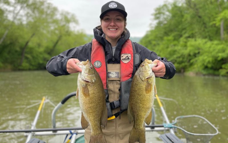
The most sought-after sportfish in the North Fork Shenandoah River is the smallmouth bass. Densities of smallmouth are high and anglers can experience catch rates that average 1.2 bass per hour. Fisheries biologists consider a catch rate greater than one fish per hour to be very good. Experienced anglers can experience catches of 50+ smallmouth in a day of fishing. Remember, fishing success can vary depending upon environmental conditions. The natural mortality rate of smallmouth in the North Fork is high and harvest by anglers is low, based on research conducted by biologists. Therefore, the smallmouth bass population is mostly influenced by environmental conditions (flood/drought). Years where there is a very successful spawn produces a strong “year-class” of bass. These strong year-classes are what makes fishing favorable. When one or two strong year-classes of bass are reaching the sizes that anglers prefer, fishing can be considered excellent. However, when weak year-classes are produced by environmental variables, fishing success can be poor. Recently, inconsistent spawning success has produced a reduction in overall numbers. Biologists and hatchery staff are attempting to boost the population by stocking fingerling smallmouth bass. With good survival anglers should see an increase in catchable sized bass in the next few years. Anglers will find smallmouth throughout all habitats on the river. One of the most productive areas to find smallmouth is directly below riffle areas or bedrock ledges. The area of the North Fork between Edinburg and Strasburg contains many bedrock ledges. Various types of artificial lures and live baits can be effective for catching smallmouth on the North Fork. Anglers should not limit their smallmouth fishing to just the warmer months. Smallmouth are active throughout the year and some of the largest bass are caught during the colder months.
Largemouth Bass
Largemouth bass are limited to relatively few areas of the North Fork where deep pools with slower currents exist. The North Fork has a low percentage of pool habitat compared to the South Fork Shenandoah. However, anglers can encounter some good largemouth fishing within the natural or dammed pools of the North Fork. Most any offering of artificial or natural bait should entice a hungry largemouth.
Sunfish
The North Fork Shenandoah River is home to several sunfish species. They include: redbreast sunfish, rock bass, bluegill, and pumpkinseed sunfish. All these sunfish species tend to occupy the same habitats. They prefer to associate with areas of reduced current and structure. The redbreast sunfish may also be in areas with faster currents. Sunfish densities are excellent and the number of larger “hand-size” panfish is outstanding. Anglers should not overlook the sunfish population when fishing the North Fork.
Fallfish
Fallfish feel right at home in the mid-depth currents of the North Fork. These fish are numerous and can attain lengths of up to 15 inches. Fallfish are often overlooked as a sportfish, but they can put up a good fight on light tackle. Fallfish often feed on the surface taking mayflies and other insects. Fly fishing for “rising” fallfish on the North Fork can be very rewarding.
Muskellunge
DWR annually stocks fingerling-size musky at several sites on the North Fork Shenandoah River from New Market to Strasburg. There has been no evidence of muskies reproducing naturally in the North Fork, therefore they must be stocked to sustain a fishery. Adult musky densities are low so anglers will need to find deeper pools to target these exciting fish.
Channel Catfish
Channel catfish are plentiful but scattered throughout the North Fork. Serious catfish anglers should target the lower reaches of the North Fork, as overall numbers increase as you move downstream. The large pools in the river are the best places to locate channel cats. Don’t overlook pieces of structure in all areas of the river, for they will also hold catfish. Anglers should take advantage of the catfish spawning season when the water temperature reaches the low-mid 60’s (F). Channel cats will move out of the deeper pools, usually heading upstream, and congregate at the head of pools in shallower water. Unlike other fish that do not feed during spawning, catfish feed heavily during this time. Even though most people think that you can only catch catfish after dark, anglers can also have success during daylight hours. Commercial catfish baits, homemade “stinkbaits”, cut bait, and some live baits can be used to catch channel catfish.
Other Fish Species
American eel, white sucker, northern hogsucker, common carp, crappie, chubs and yellow bullhead are some other fish species that anglers might encounter in the North Fork.
Shenandoah, Cowpasture, and James River Fish Kills Update
Biologist Reports
Regulations
From Route 42 bridge, Rockingham County, downstream to the confluence with the South Fork Shenandoah River at Front Royal:
- Black Bass (Smallmouth and Largemouth): 5 per day. No bass 11–14 inches can be harvested.
- Sunfish: 50 per day. No length limit
- Rock Bass: 25 per day. No length limit
- Muskellunge: 1 per day. Minimum size 40 inches
- Channel Catfish: 20 per day. No length limit
More Information
For more information about the North Fork Shenandoah River:
Fishing / boating/ general info:
Virginia Department of Wildlife Resources
Verona Office
Phone: (540) 248-9360
Camping /outfitters /fishing guides:
Shenandoah County Chamber of Commerce
Phone: (540) 459-2542
Front Royal – Warren County Chamber of Commerce
Phone: (540) 635-3185
River conditions / water levels:
United States Geological Survey
Phone: (804) 261-2600
River issues / general info:
Friends of the North Fork of The Shenandoah River
P.O. Box 746
Woodstock, VA 22664
Phone: (540) 459-8550