
By John Page Williams
Got winter blues and cabin fever? Got a boat? Go see who has come down from the frozen North to spend the winter with us here on Virginia’s tidal rivers. Pick a (relatively) warm, sunny day with calm winds to visit coastal waters where migratory waterfowl—ducks, Canada geese, and tundra swans spend the season with us. Since they are warm-blooded (and well insulated in their natural down parkas), these birds are active in cold weather, and they are here because their summer homes are frozen. Tundra swans, for example, fly around 3,000 miles from, well, Arctic tundra in Canada and Alaska to spend the winter on our rivers and the Bay’s tidal flats.
Before You Go, Get Prepared
Prowling around on the Chesapeake in mid-winter can be richly rewarding, but only if you are well prepared. First, check the Virginia Department of Wildlife Resources (DWR) hunting seasons for migratory gamebirds before you go. Be sure to respect the seasons and give blinds on these waterways a wide berth if they’re occupied. Nearly all waterfowl seasons close on January 31, so a February thaw is a great time to explore. In any case, avoid scaring or disrupting the birds unnecessarily. They’ve come a long way to winter here, as have their ancestors for at least 3,000 years. They deserve our respect and appreciation.
The DWR offers good general guidelines for about safety during winter boating and being aware of weather conditions, with Rule #1 ALWAYS being wear your life jacket. Paddlecraft are great for sneaking up quietly into marsh creeks within a mile or two of your launch point, and you’ll benefit from the heat you generate with your paddle. (Remember that “they who cut their own wood are warmed twice”.) An outboard skiff, on the other hand, will allow you greater range and still allow you to sneak into skinny places, provided you have a pushpole aboard.
If you’re new to birding, DWR can help here too: Birding Basics | Virginia DWR. Look at the Coastal Region of DWR’s Birding and Wildlife Trail for a general idea of where to go, along with some specifics on birding by land vehicle and hiking. You’ll find useful suggestions for specific birds to look for, along with a link to seasonal bird observations nearby.
So, where to go? Here are four of our favorites, on the Appomattox/Swift Creek, the Pamunkey, the Rappahannock, and the Great Wicomico, respectively. Click on the link for each launch site and read the story for general background on the area around it, plus photos.
White Bank Park
The delta of the Appomattox River extends for six miles from the head of tide at Petersburg to its junction with the James between Bermuda Hundred and City Point at Hopewell. It is full of forested swamp islands and tidal fresh marshes loaded with food like wild rice, smartweed, tearthumb, and rice cutgrass for wintering waterfowl. The public landing at White Bank Park is actually on the short tidal reach of Swift Creek, a large Appomattox tributary. Check the tide prediction for Puddledock, nearby on the Appomattox, on the website of the National Oceanic and Atmospheric Administration (NOAA).
At low tide, the channel out to the Appomattox is shallow enough to require careful piloting for birders in outboard skiffs, though those boats offer enough speed, judiciously employed, to get a good look all over the delta and even out into the broad waters where the Appomattox meets the James. Paddlecraft, on the other hand, are ideal for sneaking quietly through intimate channels like Rosemary Lane and Pye Alley.
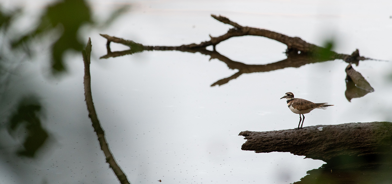
Keen eyes can catch killdeer here during winter. Photo by Luca Pfeiffer/DWR
In either kind of watercraft, it’s important to carry a navigation chart/GPS phone app, to have a sense of location and depth. Don’t get lost or stranded in there! It’s too lovely to let a winter day turn into a harrowing experience. Included in the season bird observations for the VBWT site nearby, R. Garland Dodd Park at Points of Rocks, Canada geese, mallards, mourning doves, killdeer, laughing gulls, ring-billed gulls, double-crested cormorants, Cooper’s hawks, and red-shouldered hawks have recently been spotted in the area.
Lester Manor
Lester Manor lies about halfway between the Pamunkey River’s head of tide (the Rt. 360 Bridge) and West Point, where it joins the Mattaponi to form the York. As you’ll note from the story in the link, the ramp requires care for trailered outboard boats; the vertical tide change is 3-3.5′, depending on moon phase, and the current can run as high as 2.5 knots in either direction. Check these tide and current predictions for Lester Manor on NOAA’s website.
Like the Appomattox delta, this section of the Pamunkey is full of tidal fresh marshes loaded with food like wild rice, smartweed, tearthumb, and rice cutgrass for wintering waterfowl. A great destination for paddlecraft and outboard skiffs lies across the river from Lester Manor in the sprawling Cumberland Marsh. Here, The Nature Conservancy’s Virginia Chapter operates its Vandell Nature Preserve. Spotted here recently were Canada geese, mallards, buffleheads, double-crested cormorants, great blue herons, bald eagles, and red-shouldered hawks.
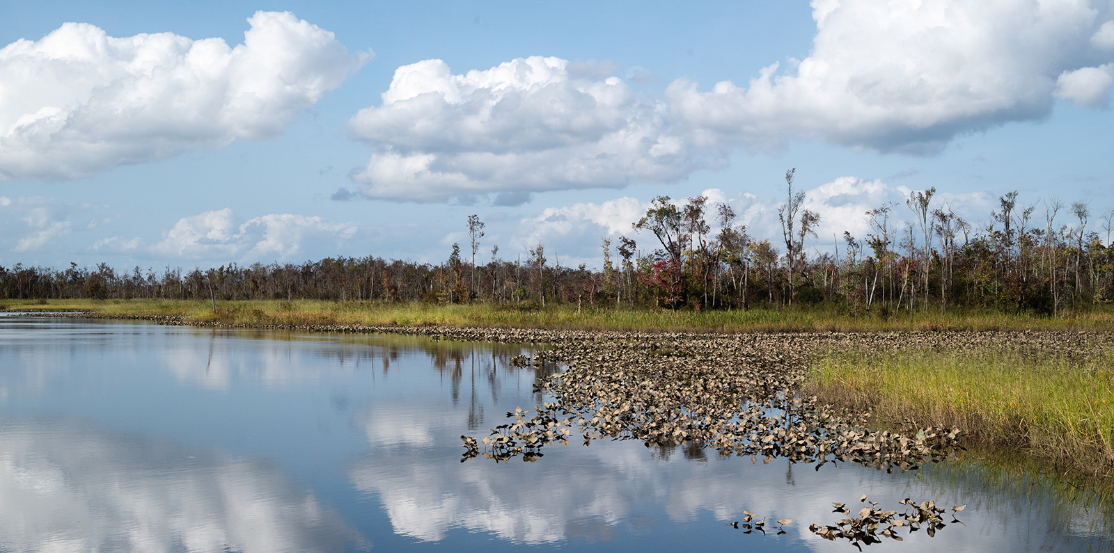
The Cumberland Marsh area is an excellent place to spot a variety of waterfowl species. Photo by Luca Pfeiffer/DWR
The Cumberland Marsh offers multiple channels and to explore. As in the Appomattox delta, it’s important to have some sort of GPS/chart phone app or sonar/chartplotter to get around the area. We also recommend you scout it on Google Earth. Beyond the Cumberland Marsh, consider exploring Cohoke Creek, two miles downstream of Lester Manor. It’s a lovely waterway that drains an historic millpond. Note from the image in Google Earth that the channel into Cohoke lies on the downstream side of the creek’s mouth.
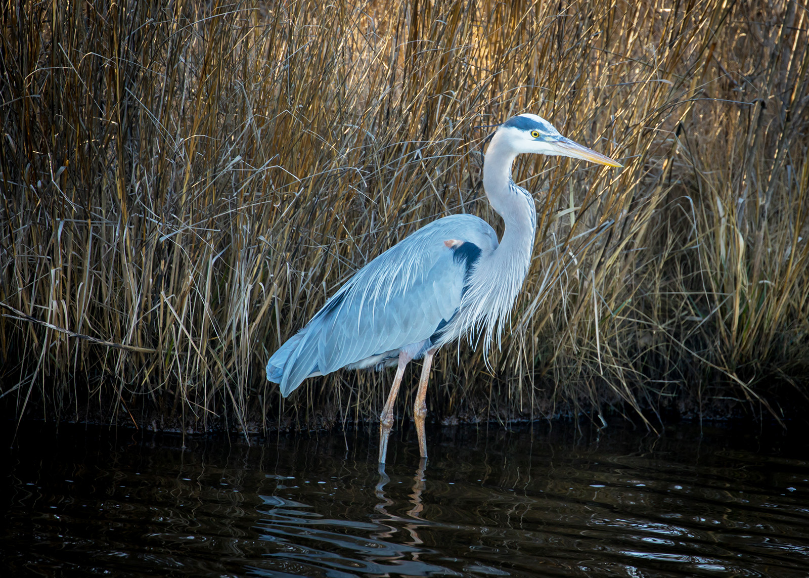
Great blue heron is one of the many species that can be spied in the Cumberland Marsh area. Photo by Meghan Marchetti/DWR
Carter’s Wharf
As you’ll read in the linked story, Carter’s Wharf lies at the bottom of a ravine in the middle of the spectacular four-mile-long Fones Cliffs on the Rappahannock. The 100-foot-high cliffs, owned and conserved by the U.S. Fish & Wildlife Service and the Rappahannock Tribe, rank high among East Coast preserves as habitat for bald eagles, but in winter, they attract migratory waterfowl as well.
Directly across the river lies the huge Beverly Marsh, a spectacular wetland protected by conservation easement. The Rappahannock here is powerful enough to demand respect at any time of year, but prudence is especially crucial in winter. Heed the cautions in the linked story and turn them up a notch for cold weather. That said, exploring the shoreline of the Cliffs and the marsh during a February thaw can produce a memorable experience. Pay close attention to wind, current (listed here for the station five miles downstream at Tappahannock), and tide (also at Tappahannock). One interesting area to explore in paddlecraft is Brockenbrough Creek at the upper end of the Cliffs, a mile upstream of Carter’s Wharf.
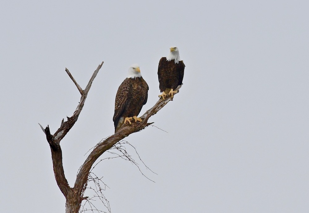
Bald eagles are commonly viewed in the Carters Wharf area. Photo by Bill Portlock
In good weather aboard an outboard skiff, consider exploring upriver past the old ports of Layton’s, Leedstown, and Saunders Wharf. On the big marshes on the insides of those curves, Otterburn and Drake’s, you should see large rafts of Canada geese. If you’re adventurous and the weather is fine, continue up to Horsehead Cliffs, part of The Nature Conservancy’s Voorhees Nature Preserve. It’s another major bald eagle magnet that also appears on DWR’s Bird and Wildlife Trail. In addition to the usual coastal suspects sighted here recently, yellow-bellied sapsuckers, red-bellied woodpeckers, northern flickers, and Carolina chickadees have been reported.
Shell Landing
Shell Landing lies on Cockrell’s Creek, just below Reedville, and there’s plenty to do around it in warm weather, as the story in the link explains. In winter, though, the primary area for waterfowl-watching is the VBWT site of Dameron’s Marsh Natural Area Preserve, owned and operated by Virginia’s Department of Conservation and Recreation (DCR). This is saltmarsh territory, on the western shore of the open Chesapeake, looking 25 miles across the open Bay to the mouth of Onancock Creek.
It’s also what coastal scientists call a high-energy shoreline, so be sure not to venture out there unless the wind is down, and pay attention to NOAA’s tide predictions, especially in an outboard skiff. Part of what makes this area special are the extensive underwater Bay grass beds that attract fish and crabs in summer and waterfowl in winter. As always, explore the area carefully and don’t disrupt the birds as they loaf, feed, and sleep.
If the weather and your choice of watercraft fit, consider exploring up the bay’s shore from Fleeton Point north toward Smith Point. Again, this is a high-energy shoreline, wide open to both southeasterly and nor’easter storms. The bottom is shallow, with offshore bars that parallel the shore. It attracts tundra swans that feed on Bay grasses and shellfish like small softshell clams. Don’t even think about it, though, in any sort of easterly winds. (We speak from scary experience.) Shell Landing offers an experience very different from the other three sites in this list. If you can make it work safely, it’s spectacular, but don’t take chances here.
John Page Williams is a noted writer, angler, educator, naturalist, and conservationist. In more than 40 years at the Chesapeake Bay Foundation, Virginia native John Page championed the Bay’s causes and educated countless people about its history and biology.
